705: CHINA STRENGTHENS SPACE STATION OPERATIONS WITH TIANZHOU-9 RESUPPLY MISSION


My article was published on “The EurasianTimes” website

on 16 Jul 25.


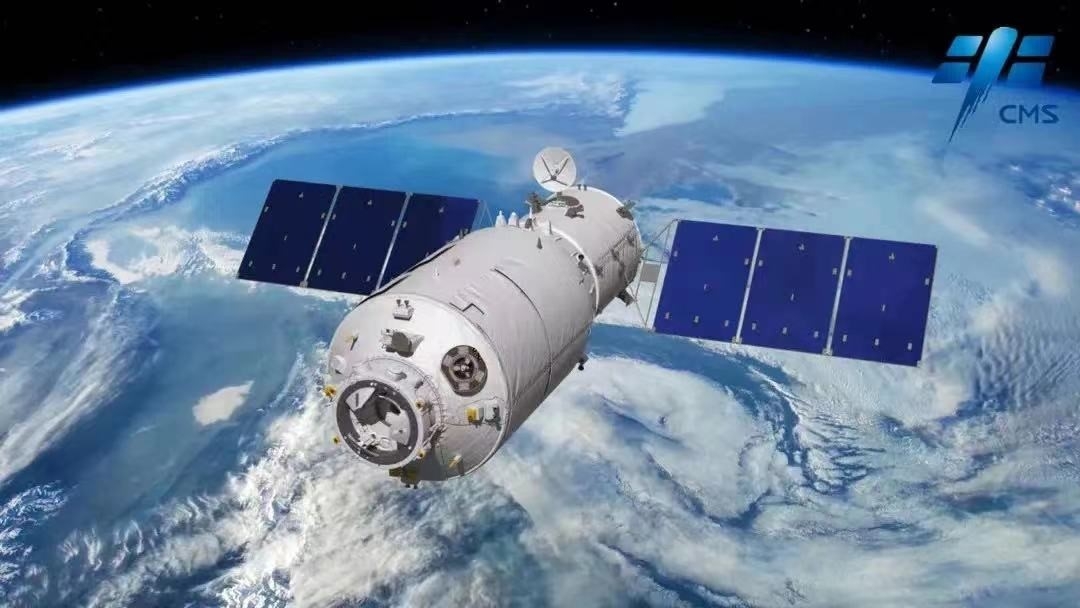
On July 15, 2025, at 5:34 a.m. Beijing Time, China commemorated another milestone in its ambitious space program with the successful launch of the Tianzhou-9 cargo spacecraft from the Wenchang Spacecraft Launch Site in Hainan Province. Tianzhou-9 ascended into the predawn sky to deliver essential cargo supplies to the Tiangong space station, China’s orbiting outpost in low Earth orbit.

Launched aboard a Long March-7 Y10 rocket from the Wenchang Space Launch Site in Hainan Province, Tianzhou-9 reached orbit approximately 10 minutes after lift-off. Just over three hours later, it autonomously docked with the Tiangong station’s Tianhe core module, completing a rapid and exact rendezvous manoeuvre. This fast and precise docking underscores the maturity of China’s automated rendezvous and docking technology, a crucial capability for sustaining long-term space missions.

This mission represents the fourth cargo resupply flight since Tiangong entered its application and development phase. The mission highlights China’s increasing confidence in orbital logistics and its capacity to sustain an independent, fully operational space station.


Tianzhou-9’s Cargo

Tianzhou-9 reportedly carried between 6.5 and 7.2 tonnes of cargo, comprising essential living supplies, advanced hardware, and a wide array of scientific instruments. Among the mission’s most notable payloads were two upgraded extravehicular activity (EVA) spacesuits. These new-generation suits boast improved durability, with a lifespan of four years and the capacity to support up to 20 spacewalks. These enhancements will enable taikonauts aboard Tiangong to carry out longer, more frequent, and safer operations outside the station.

In addition to the EVA suits, Tianzhou-9 brought a new core-muscle training device designed to help astronauts maintain muscle strength and mitigate the effects of extended weightlessness. Physical health in microgravity is a key concern for long-duration missions, and this device will contribute to China’s research into space physiology and crew health maintenance.

One of the most innovative scientific payloads onboard was a brain organoid-on-a-chip experiment. This sophisticated biological test aims to replicate human brain cells under microgravity conditions, examining the functionality of the blood–brain barrier in space. The research has the potential to provide valuable insights into the cognitive and neurological risks encountered by astronauts during extended space missions. It could contribute to the development of future countermeasures.

Also included in the cargo were nanocarrier-based drug delivery systems, materials science experiments, and tools for aerospace medicine studies. The spacecraft also carried consumables such as food, water, and oxygen for the crew of Shenzhou-20 currently residing on the space station, as well as propellant to help Tiangong maintain its orbit and perform attitude adjustments. These supplies are essential for maintaining the habitability of Tiangong, which has been operational since its core module was launched in April 2021.


A Critical Link in the Tiangong Ecosystem

The Tiangong space station, currently in its application and development stage, marks a major advancement in China’s space ambitions. Unlike earlier testbed stations, Tiangong is a modular, permanent platform designed to compete with the International Space Station (ISS). It consists of the Tianhe core module and the Wentian and Mengtian experimental modules, enabling a broad spectrum of scientific research, technological tests, and crew activities.

As Tiangong matures into a fully operational orbital laboratory, the Tianzhou series of cargo spacecraft provides the logistical backbone to maintain its operation smoothly. With a payload capacity exceeding 6.5 tonnes and autonomous docking capabilities, Tianzhou spacecraft are comparable to other international resupply systems, such as SpaceX’s Dragon, Russia’s Progress, and Northrop Grumman’s Cygnus vehicles.

Each Tianzhou launch not only replenishes life-support essentials but also delivers a suite of scientific instruments to support China’s growing space research program. By regularly rotating crews and resupplying the station, CMSA ensures that Tiangong remains a vibrant hub for microgravity research, life sciences, materials development, and advanced technologies.


China’s Broader Space Strategy and Global Ambitions

China’s space program operates independently of other leading spacefaring nations, primarily due to geopolitical constraints, including U.S. legislation that restricts NASA’s collaboration with China. Consequently, Tiangong exemplifies China’s independence in space technology. From launch vehicles to spacecraft and ground infrastructure, all elements of the Tiangong program are developed domestically, demonstrating China’s engineering prowess.

China’s consistent success in human spaceflight and station operations reflects its long-term ambitions to become a dominant spacefaring nation. The Tianzhou-9 mission represents merely the latest in a series of accomplishments that include landing rovers on the Moon and Mars, launching the world’s largest radio telescope, and sending up a relay satellite to support future lunar missions.

Furthermore, the operation of China’s space station offers invaluable expertise for subsequent deep-space expeditions. The competencies acquired in spacecraft docking, extended human habitation, robotic management, and onboard medical research constitute essential foundational skills for prospective missions to the Moon or Mars.


Global Context

The Tianzhou-9 mission comes at a time when global interest in space exploration is surging. The ISS, a collaborative effort involving the U.S., Russia, Europe, Japan, and Canada, is nearing the end of its operational life, with planned decommissioning in 2030. Tiangong, by contrast, is a relatively new platform, positioning China as a key player in the next era of human spaceflight. While Tiangong is smaller than the ISS, its capabilities are robust, and its scientific output is growing.

China has expressed a willingness to cooperate internationally regarding the Tiangong space station, extending invitations to other nations to conduct experiments aboard the facility. This initiative may facilitate the development of partnerships with countries across Asia, Africa, and other regions, particularly those without established space programs. Such collaborations possess the potential to redefine the geopolitics of outer space, fostering new alliances and avenues for scientific advancement.


Future Prospects

In 2025, China is expected to launch Shenzhou-21, which will carry a new crew to the space station. The incoming team will relieve the current taikonauts and proceed with the ongoing scientific research, while also preparing for future enhancements to the station’s infrastructure.

Beyond Tiangong, China is also formulating plans to deploy astronauts on the Moon before 2030. The Tianzhou and Shenzhou missions will function as essential training platforms for life support systems, crew rotations, and logistical supply chains necessary for such sustained undertakings.


Conclusion

The launch of Tianzhou-9 symbolises more than merely another cargo delivery; it exemplifies China’s rapidly progressing capabilities in space logistics, engineering expertise, and increasing leadership in orbital sciences. With each successive mission, China advances towards realising its vision of establishing itself as a preeminent entity in human spaceflight and space-based research. As the Tiangong space station develops into an international platform for scientific and technological endeavours, global attention remains focused. Tianzhou-9 has not only provided the necessary hardware and experiments to support this future but has also reaffirmed China’s preparedness to spearhead the forthcoming era of space exploration.


Please Add Value to the write-up with your views on the subject.


1995
Default rating

Please give a thumbs up if you  like The Post?


Link to the article on the website:-

Big Milestone For China’s Space Program! Beijing Masters Logistics For Tiangong’s Cosmic Future With Tianzhou-9 Resupply Mission


For regular updates, please register your email here:-

Subscribe


References and credits

To all the online sites and channels.

Pics Courtesy: Internet

Disclaimer:

Information and data included in the blog are for educational & non-commercial purposes only and have been carefully adapted, excerpted, or edited from reliable and accurate sources. All copyrighted material belongs to respective owners and is provided only for wider dissemination.


References:

China Manned Space Agency. (2025, July 15). Tianzhou-9 docks with Tiangong space station. Xinhua News.

Howell, E. (2025, July 15). China launches Tianzhou 9 cargo spacecraft to Tiangong space station. Space.com. Retrieved from https://www.space.com

Global Times. (2025, July 15). Tianzhou-9 brings upgraded EVA suits, brain organoid experiments to Tiangong. Retrieved from https://www.globaltimes.cn

Jones, A. (2025, July 16). Tianzhou-9 Bolsters China’s Tiangong Space Station with Critical Supplies and Experiments. The Planetary Society Blog.

People’s Daily. (2025, July 15). China Advances Its Space Program with the Launch of Tianzhou-9 from Wenchang—People’s Daily Online.

CCTV News. (2025, July 15). Tianzhou-9 Successfully Launched, Strengthening Tiangong’s Capabilities. China Central Television.

China National Space Administration (CNSA). (2025). Mission overview: Tianzhou and Tiangong programs. Retrieved from http://www.cnsa.gov.cn

CGTN. (2025, July 15). Tianzhou-9 launch completes rapid autonomous docking with Tiangong. CGTN News.

Xinhua News Agency. (2025, July 15). China Sends Tianzhou-9 Cargo Spacecraft to Supply Tiangong Space Station. Xinhua Net.

SpaceNews. (2025, July 15). China’s Tianzhou-9 Cargo Mission Supports Tiangong with Supplies for Shenzhou-20 and Shenzhou-21 Crews. SpaceNews.

677: NISAR: MAPPING THE FUTURE AND REVOLUTIONISING CLIMATE AND DISASTER INTELLIGENCE


My article was published in the Jun edition of the

News Analytics Journal


In an era where climate change, natural disasters, and ecological degradation are becoming more pressing global concerns, advanced space-based Earth observation has emerged as a vital tool. The NASA-ISRO Synthetic Aperture Radar (NISAR) mission is a landmark collaboration between the National Aeronautics and Space Administration (NASA) and the Indian Space Research Organisation (ISRO).

NISAR represents the most advanced dual-frequency radar satellite ever developed for civilian use. Once operational, NISAR will monitor Earth’s land and ice surfaces with high precision. It will capture surface movements down to fractions of an inch, aiding in studying tectonic shifts, glacier dynamics, forest health, and infrastructure stability.​ It can transform how we understand and respond to changes on Earth’s surface, ranging from glacial movements to forest biomass, from seismic activity to urban land subsidence.

The latest update on the NASA-ISRO Synthetic Aperture Radar (NISAR) mission indicates that the launch is scheduled for late May to June 2025, a shift from the anticipated March 2025 timeline. This delay, caused by thermal coating issues with the 12-meter radar antenna reflector, was resolved by October 2024. Despite the delay, the mission’s objectives and timeline remain intact. Final integration and testing are underway at ISRO’s facilities in Bengaluru. The satellite is expected to be transported to the Satish Dhawan Space Centre in the coming weeks to prepare for its launch aboard a GSLV Mark II rocket.​


NISAR Project: Collaborative Effort


Genesis. The NISAR mission concept emerged from NASA’s 2007 Decadal Survey, which called for advanced SAR data to address gaps in Earth science. Formalised in 2014 with a partnership agreement, the project has progressed through rigorous design, testing, and integration phases. NASA’s Jet Propulsion Laboratory (JPL) and ISRO’s Space Applications Centre have worked closely to refine the mission’s science plan and hardware.

Project Details. The NISAR mission is designed to provide unprecedented global radar imagery using L-band and S-band synthetic aperture radars. NASA has provided the L-band radar system, high-rate communication subsystem, GPS receivers, and payload data systems. ISRO is contributing the S-band radar, satellite bus, and launch services via the GSLV Mk II from the Satish Dhawan Space Centre. The satellite will be placed in a sun-synchronous polar orbit at about 747 kilometres and revisit the exact location on Earth every 12 days. The SAR payload will produce radar images with a resolution of 5–10 meters and a swath of 240 kilometres, enabling wide-area monitoring of Earth’s surface with high precision. The unique dual-band system of NISAR allows it to penetrate vegetation, ice, and soil more accurately than single-frequency satellites, making it a game-changer in Earth observation. The L-band is particularly effective for tracking subsurface movement and biomass, while the S-band is more sensitive to finer surface features.

Collaboration. The NISAR partnership exemplifies international cooperation in space exploration. NASA’s investment, estimated at $1.118 billion, covers the L-band radar and critical subsystems, while ISRO’s contribution, approximately ₹788 crore ($92 million), includes the S-band radar, spacecraft bus, and launch services. This division of responsibilities optimises costs and expertise, building on NASA’s legacy of SAR missions (e.g., SEASAT in 1978) and ISRO’s advancements in satellite technology (e.g., the Chandrayaan missions). The collaboration extends beyond hardware. Joint workshops, working groups, and the NISAR Utilisation Programme announced by ISRO in July 2023 engage the global scientific community, fostering data analysis and application development. The mission’s open data policy aligns with the principles of transparency and collaboration, setting a precedent for future NASA-ISRO endeavours, including potential Mars exploration missions.


Mission Objectives and Scientific Impact

NISAR’s primary goal is to make global measurements of land surface changes, detecting movements as small as a centimeter. By mapping the globe every 12 days, the satellite will generate spatially and temporally consistent data, offering insights into complex Earth processes. Its objectives span three key domains: deformation, ecosystem structure, and ice dynamics. NISAR will monitor seismic zones, volcanic activity, and landslide-prone areas for deformation, providing early warning signs for natural disasters. In ecosystem studies, it will track forest extent, vegetation biomass, and agricultural patterns, aiding sustainable resource management. NISAR will measure glacier flow rates and ice-sheet stability for ice dynamics, contributing to our understanding of climate change and sea level rise.

All NISAR data will be freely available within one to two days of observation or hours for emergencies like natural disasters. This accessibility and NISAR’s high-resolution imagery (5-10 meters) will empower scientists, policymakers, and disaster response teams worldwide. The data can enhance infrastructure monitoring, improve agricultural management, and inform rapid disaster response, potentially saving lives and property. The open data policy also encourages collaboration and innovation, allowing for the development of new applications and tools to further leverage NISAR’s capabilities.


Applications

Natural Disaster Monitoring and Response. NISAR will be critical in mapping the aftermath and precursors of earthquakes, floods, volcanic eruptions, and landslides. The radar’s ability to detect minute ground deformations will help forecast and emergency response, reducing the human and economic cost of such events.

Climate Change Observation. The satellite will track ice sheet movement in Antarctica and Greenland, glacial retreat in the Himalayas, and coastal subsidence, all critical indicators of global climate change. NISAR data will also assist in modelling sea level rise and understanding the behaviour of the permafrost regions, which store vast amounts of greenhouse gases.

Agriculture and Forestry. NISAR’s radar can estimate biomass and crop yield, making it invaluable for food security planning and carbon stock assessment. It will monitor deforestation, forest degradation, and land-use changes, helping countries meet international commitments such as those under the Paris Agreement and REDD+ initiatives.

Urban Infrastructure Monitoring. Urban planners and disaster mitigation agencies can use NISAR to monitor growing cities’ subsidence, groundwater depletion, and infrastructure stress. Its precise deformation measurements can help predict building collapses, dam failures, and roadbed weaknesses.

Scientific and Tectonic Research. Scientists will use NISAR to understand better plate tectonics, fault line dynamics, and volcano formation. The L-band radar, in particular, is ideal for detecting ground movements as small as a few millimetres, critical for early warnings in earthquake-prone regions.

Strategic Significance

The NISAR mission is a scientific milestone and a strategic symbol of the growing India-US partnership in space technology. It reflects significant technological trust and collaborative capacity-building, especially as China expands its space and Earth observation programs.

For India, the mission provides access to advanced radar imaging technology, enhances its global space diplomacy profile, and contributes to developing disaster management and environmental monitoring capacity. For the U.S., NISAR extends Earth observation to low-latitude and tropical regions, which are difficult to monitor from NASA’s polar-focused satellites.


Conclusion

NISAR stands at the intersection of science, diplomacy, and strategic policy. As the world’s most advanced Earth-observing radar satellite, it will provide a detailed, dynamic picture of the planet’s changing surface. Whether helping farmers optimise irrigation, supporting relief efforts after natural disasters, or aiding climate scientists in tracking global warming, NISAR will become an indispensable part of humanity’s Earth-monitoring infrastructure.

By combining ISRO’s cost-effective engineering and operational expertise with NASA’s deep technological experience, NISAR heralds a new era in Earth observation and exemplifies the international collaboration required to tackle global challenges.


Please Add Value to the write-up with your views on the subject.

1995
Default rating

Please give a thumbs up if you  like The Post?


For regular updates, please register your email here:-

Subscribe


References and credits

To all the online sites and channels.

Pics Courtesy: Internet

Disclaimer:

Information and data included in the blog are for educational & non-commercial purposes only and have been carefully adapted, excerpted, or edited from reliable and accurate sources. All copyrighted material belongs to respective owners and is provided only for wider dissemination.


References: –

  1. Indian Space Research Organisation. (2024). NASA-ISRO SAR (NISAR) Mission Overview. Retrieved from https://www.isro.gov.in
  1. NASA Earth Science Division. (2023). NISAR Mission Overview. https://nisar.jpl.nasa.gov
  1. NASA Jet Propulsion Laboratory. (2024). NISAR: NASA-ISRO Synthetic Aperture Radar. https://nisar.jpl.nasa.gov
  1. ESA Earth Observation Portal. (2023). Synthetic Aperture Radar Applications in Climate and Disaster Monitoring.
  1. United Nations Office for Disaster Risk Reduction (UNDRR). (2023). Role of Earth Observation in Risk Reduction.
  1. Sharma, A. & Kumar, R. (2022). “India-US Space Cooperation: Strategic Implications.” ORF Occasional Paper, Observer Research Foundation.
  1. Ray, P. (2023). “Climate Resilience through Satellite Monitoring in South Asia.” Nature Climate Policy, 15(3), 410-417.
  1. Rosen, P. A. (2021). The NASA-ISRO Synthetic Aperture Radar (NISAR) Mission – Technologies and Techniques for Earth Science. NASA Technical Reports Server. https://ntrs.nasa.gov
  1. Ramachandran, R. (2024). “Thermal coating issue fixed on NASA-ISRO NISAR mission.” The Hindu Science & Tech. https://www.thehindu.com
  1. Nayak, A., & Kumar, P. (2023). “SAR Technology for Earth Observation: Advances with the NISAR Mission.” Current Science, 125(9), 1463–1471.
  1. Prasad, S., & Mehta, K. (2022). “Earth Observation and Indian Disaster Management.” Journal of Geospatial Technologies, 14(2), 91–104.

669: INDIA’S PERSISTENT EYES IN THE SKY: STRATOSPHERIC AIRSHIP PLATFORMS


My article was published on “The EurasianTimes” website

on 05 May 25.


On May 3, 2025, India’s Defence Research and Development Organisation (DRDO) achieved a significant milestone by successfully conducting the maiden flight trial of its Stratospheric Airship Platform at Sheopur, Madhya Pradesh. Developed by the Aerial Delivery Research and Development Establishment (ADRDE) in Agra, the lighter-than-air platform reached an altitude of 17 km, carrying an instrumental payload during a 62-minute flight. The test validated critical systems, including envelope pressure control and emergency deflation mechanisms, with sensor data collected to refine high-fidelity simulation models for future missions. Defence Minister Rajnath Singh and DRDO Chairman Dr. Samir V. Kamat hailed the achievement, emphasising its potential to enhance India’s earth observation, intelligence, surveillance, and reconnaissance (ISR) capabilities. This positions India among a select few nations with indigenous stratospheric airship technology. The successful trial, conducted amid heightened India-Pakistan tensions, underscores DRDO’s focus on advancing high-altitude, long-endurance platforms to bolster national security and surveillance, marking a pivotal step toward operationalising these pseudo-satellite systems.


Stratospheric Airships

In an era where connectivity, surveillance, and environmental monitoring are paramount, the innovative stratospheric airship platforms, high-altitude, lighter-than-air vehicles operating at 20–30 km, offer a transformative solution. These unmanned, long-endurance systems, often called High-Altitude Platform Systems (HAPS), combine satellites’ endurance with terrestrial systems’ flexibility. Positioned above commercial air traffic and weather systems, they promise to deliver telecommunications, intelligence, surveillance, reconnaissance (ISR), and scientific research at a fraction of the cost of traditional satellites.

Technology. Stratospheric airships are aerostatic vehicles that rely on helium-filled envelopes for buoyancy, allowing them to float in the low-density air of the stratosphere. Unlike fixed-wing HAPS or balloons, airships use propulsion systems, typically electric motors powered by solar panels or hydrogen-based regenerative fuel cells (RFCs), to maintain station-keeping or navigate over specific regions. Their design incorporates lightweight, UV-resistant materials to withstand harsh stratospheric conditions, including temperatures as low as -60°C, intense ultraviolet radiation, and ozone corrosion.

Components. The primary technical challenges include developing lightweight materials, optimising energy efficiency, ensuring thermal management, and achieving reliable control in a near-vacuum environment. These hurdles have historically delayed operational deployment, but recent advancements are closing the gap. Key technological components include:-

    • Envelope and Materials. The helium-filled envelope, often made of advanced composites like polyethene or Mylar, must balance strength, weight, and durability. Innovations in nanotechnology and multi-layered fabrics enhance resistance to environmental degradation.
    •  Power Systems. Solar panels and energy storage (batteries or RFCs) enable continuous operation. RFCs, which generate electricity by combining hydrogen and oxygen, are particularly promising for long-endurance missions, as demonstrated in Japan’s Stratospheric Platform (SPF) program.
    • Payload. Airships carry modular payloads (20–1,500 kg) tailored to specific missions, such as phased-array antennas for 4G/5G connectivity, high-resolution cameras for ISR, or sensors for environmental monitoring.
    • Control Systems. Autonomous navigation and station-keeping require sophisticated algorithms to counter stratospheric winds, which are milder than jet streams but still challenging. Machine learning and real-time data processing are increasingly integrated for precision.


Applications

Stratospheric airships are versatile platforms with applications across civilian, commercial, and military domains. These applications position stratospheric airships as a cost-effective alternative to satellites, with the added benefit of reusability and rapid deployment.

Telecommunications. Airships can provide broadband connectivity to remote or underserved regions, acting as “pseudo-satellites.” For instance, Mira Aerospace’s ApusDuo HAPS delivered 5G connectivity in Rwanda in 2023, demonstrating the potential to bridge the digital divide. Unlike satellites, airships can be repositioned or serviced, offering flexibility for dynamic network demands.

Intelligence, Surveillance, Reconnaissance (ISR). Their ability to loiter over specific areas for extended periods makes airships ideal for ISR.

Environmental Monitoring. Airships with sensors can monitor greenhouse gases, climate patterns, or natural disasters. Sceye Inc., a New Mexico-based company, is developing airships to track environmental changes, supporting global sustainability efforts.

Scientific Research. High-altitude platforms enable ground-breaking scientific research, such as atmospheric studies, astronomy, and other research requiring stable, high-altitude vantage points. NASA’s proposed Centennial Challenge aims to incentivise airship innovations for scientific missions, inspiring a new era of discovery.

Military Applications. Beyond ISR, airships could support GPS jamming, missile defence, wartime communications, electronic warfare and the potential for stealth detection.


Advantages & Limitations

Advantages. Stratospheric airships provide compelling advantages over traditional platforms like satellites. Their cost-effectiveness is a key benefit, with development, launch, and maintenance costs in the millions, far below the billions required for satellites. This affordability democratises access to high-altitude capabilities. Flexibility is another strength; unlike geostationary satellites, airships can be repositioned, serviced, or upgraded to meet evolving mission needs, enabling dynamic applications such as telecommunications or surveillance. Their long endurance—capable of missions lasting months or even years—reduces the need for frequent replacements, enhancing operational efficiency. Additionally, accessibility is improved by operating below orbital altitudes, avoiding the complexities of space debris and stringent international space regulations. These attributes make stratospheric airships an attractive alternative for tasks like broadband delivery, environmental monitoring, and intelligence gathering, offering a versatile, cost-efficient bridge between terrestrial and space-based systems.

Limitations. Stratospheric airship platforms face significant limitations that hinder their widespread adoption. Technical complexity remains a primary challenge, as lightweight materials, efficient energy storage, and precise control systems require further development to ensure reliability in the harsh stratospheric environment. Limited operational systems exacerbate this issue, with most airships still in the prototype phase and scarce real-world flight data to validate performance. Environmental challenges also pose risks, as stratospheric conditions—extreme cold, UV radiation, and ozone exposure—demand robust designs to prevent envelope degradation or thermal failures. Additionally, regulatory hurdles complicate deployment, as coordinating airspace usage and navigating international regulations, particularly for cross-border missions, remains a barrier. These challenges necessitate substantial investment in research, testing, and regulatory frameworks to transition stratospheric airships from experimental to operational systems, unlocking their potential for telecommunications, surveillance, and environmental monitoring.


Development status

The concept of stratospheric airships, pioneered in the 1960s with Raven Aerostar’s High Platform II reaching 70,000 ft in 1969, gained traction in the 1990s as materials and solar technology advanced. Despite high costs and complexity, recent global efforts signal a resurgence, driven by improved designs and commercial potential, as seen in Google’s Loon (2013–2021).

United States. The U.S. pursued stratospheric airships through Lockheed Martin’s High Altitude Airship (HAA) and DARPA’s ISIS for ISR, but both were cancelled due to cost overruns. Aerostar’s HiSentinel reached 74,000 ft in 2005, proving viability. Sceye Inc. now leads the scaling of solar-powered airships in New Mexico for broadband and environmental monitoring, with expansion planned for 2025.

 Japan. Japan’s JAXA launched the Stratospheric Platform (SPF) in the 1990s, focusing on solar-powered airships with regenerative fuel cells. Prototypes were tested, but the program shifted focus by 2009. Japan’s early work on energy systems remains influential for long-endurance HAPS development.

South Korea and Europe. South Korea explored HAPS in the 2000s with limited outcomes. In Europe, Thales Alenia Space’s Stratobus targets ISR and telecom, aiming for five-year missions with a 2023 prototype. The TAO Group’s SkyDragon introduces a segmented design for stability, enhancing European innovation.

 China. China’s Yuanmeng airship, tested in 2015, focuses on military surveillance and stealth detection. Ongoing programs by the Aviation Industry Corporation of China emphasise long-endurance airships for communication and reconnaissance.


Future Prospects

The future of stratospheric airships is bright, driven by technological advancements. Innovations in nanotechnology and composite fabrics will produce lighter, more durable envelopes, extending mission durations. Next-generation regenerative fuel cells (RFCs) and high-efficiency solar cells will ensure reliable power, critical for continuous operation in the stratosphere. Enhanced by machine learning and real-time wind modelling, autonomous control systems will improve station-keeping precision, minimising energy use. These developments will enable airships to loiter for months or years, offering cost-effective alternatives to satellites. By addressing technical challenges, stratospheric airships are poised to revolutionise telecommunications, surveillance, and environmental monitoring by 2030.

Commercialisation and global collaboration are accelerating progress. Companies like Sceye and Stratospheric Platforms are securing investments, reflecting market confidence in high-altitude platform systems (HAPS) for connectivity and monitoring. NASA’s proposed Centennial Challenge could spur international innovation, while public-private partnerships may streamline development. However, scaling production, reducing costs, and validating reliability through extended flight tests remain critical hurdles. If overcome, stratospheric airships could become mainstream solutions, particularly in regions lacking satellite or terrestrial infrastructure, transforming global access to data and security.


Conclusion

Stratospheric airship platforms represent a frontier in high-altitude technology, blending satellites’ endurance with terrestrial systems’ adaptability. From providing broadband in remote areas to enhancing military surveillance and monitoring climate change, their applications are vast and transformative. While historical efforts faced setbacks, recent advancements, such as India’s 2025 test, Sceye’s commercial push, and Thales’ Stratobus, signal a new era of viability. As materials, energy systems, and controls evolve, stratospheric airships are poised to redefine global connectivity, security, and scientific exploration, soaring to new heights in the decades ahead.


Please Add Value to the write-up with your views on the subject.


1995
Default rating

Please give a thumbs up if you  like The Post?


For regular updates, please register your email here:-

Subscribe


References and credits

To all the online sites and channels.

Pics Courtesy: Internet

Disclaimer:

Information and data included in the blog are for educational & non-commercial purposes only and have been carefully adapted, excerpted, or edited from reliable and accurate sources. All copyrighted material belongs to respective owners and is provided only for wider dissemination.


References:-

  1. Aerial Delivery Research and Development Establishment. (2025, May 4). DRDO conducts maiden flight trial of stratospheric airship platform. Press Release, Defence Research and Development Organisation. https://www.drdo.gov.in/press-release/drdo-conducts-maiden-flight-trial-stratospheric-airship-platform
  1. Boucher, R. J. (1985). History of solar-powered airships: From High Platform II to modern HAPS. Journal of Aerospace Engineering, 1(2), 45–56. https://doi.org/10.1061/(ASCE)0893-1321(1985)1:2(45)
  1. Chen, L., & Zhang, H. (2016). Development of the Yuanmeng stratospheric airship for military applications. Chinese Journal of Aeronautics, 29(4), 912–920. https://doi.org/10.1016/j.cja.2016.06.015
  1. Colozza, A., & Dolce, J. L. (2005). High-altitude airship platform systems: Technical challenges and opportunities. NASA Technical Report, NASA/TM-2005-213427. https://ntrs.nasa.gov/citations/20050182976
  1. Japan Aerospace Exploration Agency. (2009). Stratospheric Platform (SPF) program: Final report on solar-powered airship prototypes. JAXA Technical Report, JAXA-RR-09-012. https://www.jaxa.jp/publications/
  1. Mira Aerospace. (2023, August 15). ApusDuo HAPS delivers 5G connectivity in Rwanda. Aerospace Technology News. https://www.aerospacetechnews.com/mira-aerospace-apusduo-5g-rwanda-2023
  1. Sceye Inc. (2024, December 10). Sceye advances stratospheric airship production for broadband and environmental monitoring. Business Wire. https://www.businesswire.com/news/sceye-stratospheric-airship-expansion-2025
  1. Thales Alenia Space. (2023, June 20). Stratobus: Progress toward 2023 prototype for ISR and telecommunications. Thales Group Press Release. https://www.thalesgroup.com/en/stratobus-2023-prototype-update
  1. Tozer, T. C., & Grace, D. (2001). High-altitude platforms for wireless communications. Electronics & Communication Engineering Journal, 13(3), 127–137. https://doi.org/10.1049/ecej:20010303
  1. Yang, Y., & Wu, J. (2018). Advancements in regenerative fuel cells for stratospheric airships. Energy Conversion and Management, 175, 89–98. https://doi.org/10.1016/j.enconman.2018.08.072
English हिंदी