817: HISTORICAL PERSPECTIVE ON THE INDIA–CHINA BOUNDARY DISPUTE


(The line that was never agreed upon)


Stretching from the Karakoram ranges in the west to the forested hills of Arunachal Pradesh in the east (approximately 3,488 kilometres) is the boundary between India and China, which occupies Tibet. It is not a border that was drawn, agreed upon, demarcated, and then disputed. It is a frontier that was never fully settled in the first place. It is a line that exists, as a matter of competing cartographic assertions rooted in imperial history, post-colonial nationalism, and unresolved strategic calculation.

To understand why Indian and Chinese soldiers confronted each other with lethal consequences at Galwan in June 2020, one must go back not merely decades but centuries. The boundary dispute is, at its core, a collision between the territorial inheritance of the British Indian Empire, the historical assertions of Imperial China, the revolutionary confidence of the People’s Republic of China, and the aspirational sovereignty of independent India. All of these forces remain alive in the dispute today.


Genesis of the Problem

The problem did not exist till the nineteenth century. It became one as the British Empire pushed its frontiers toward the Himalayas. British India’s interest in the Himalayan frontier was driven primarily by the strategic competition with Tsarist Russia for influence over Central Asia. A clearly defined, defensible northern frontier was a British strategic imperative. From the 1860s onward, British surveyors, explorers, and political officers pushed into Ladakh, Sikkim, and the northeastern frontier with the dual purpose of mapping the terrain and establishing the reach of British Indian sovereignty.

The critical complication was Tibet. Britain’s preferred outcome was a Tibet autonomous enough to serve as a buffer against Russian or Chinese encroachment, but within a broad sphere of British influence. The 1904 Younghusband Expedition to Lhasa was an expression of this policy. It was an extraordinary and controversial mission that forced a treaty on the Tibetan government.

The Qing dynasty’s response was to reassert direct control over Tibet, sending military expeditions in 1910 that briefly occupied Lhasa and forced the Dalai Lama into exile in British India. The Qing’s collapse in 1911 reversed this, and Tibet declared independence (not recognised by China).  The genesis of the boundary dispute lies in the status of Tibet. Tibet’s boundaries with British India were precisely the boundaries that India inherited in 1947, and that China refused to accept when it absorbed Tibet in 1950.


Colonial Cartographic Legacy

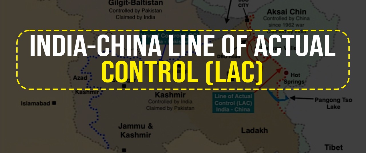
The Western Sector: Aksai Chin. Aksai Chin is a high-altitude desert plateau roughly the size of Switzerland, sitting at the intersection of Ladakh, Tibet, and Xinjiang. It is one of the most inhospitable places on earth. The boundary in this sector was never formally agreed upon between British India and either the Qing dynasty or, subsequently, the Republic of China. Different alignment proposals emerged from the British period, each reflecting different strategic priorities, none the product of bilateral agreement.

    • Johnson Line of 1865. Civil servant W.H. Johnson formulated it and was later modified by Major General John Ardagh. It placed the entire Aksai Chin plateau inside Jammu and Kashmir by extending the boundary northward to the Kunlun Mountains. It is the historical basis for India’s modern territorial claim.
    • Macartney-MacDonald Line of 1899. It was proposed to the Qing government by Sir Claude MacDonald. The British strategic priorities had shifted toward conciliating China against Russia. It proposed that the Karakoram range be used as the frontier and that most of Aksai Chin be placed under Chinese administration. The Qing government never formally responded to this proposal. China now asserts by it.

The Eastern Sector. The eastern sector’s origins lie in the Simla Convention of 1914, a tripartite conference among British India, Tibet, and the Republic of China. The British representative, Sir Henry McMahon, negotiated directly with Tibetan representatives and, through an exchange of notes, established a boundary between British India and Tibet running along the highest ridgeline of the eastern Himalayas. This alignment, known as the McMahon Line, ran approximately 890 kilometres from the Bhutan border eastward to the bend of the Brahmaputra and placed approximately 90,000 square kilometres of territory, now the state of Arunachal Pradesh, within British India. The Chinese representative at Simla initialled the convention but refused to formally ratify it, objecting both to the proposed internal division of Tibet into Inner and Outer zones and to the fundamental premise that Tibet possessed the sovereign authority to conclude treaties independently of China. China has consistently maintained that the McMahon Line is illegal as it was negotiated without the Chinese consent. China refers to Arunachal Pradesh as “South Tibet” or Zangnan, with particular emphasis on the town of Tawang, which carries deep religious and historical significance as a major centre of Tibetan Buddhism. India considers the McMahon Line as a valid international boundary.


Post-Colonial Differences (1947 to 1959)

India’s independence in 1947 and the establishment of the People’s Republic of China in 1949 initially produced not confrontation but an era of proclaimed Asian solidarity. India was among the first non-communist countries to recognise the People’s Republic. Hindi-Chini Bhai-Bhai was the slogan of the early 1950s. It reflected Jawaharlal Nehru’s genuine belief in Asian cooperation as the organising principle of post-colonial international relations.

The geopolitical cushion between the two countries vanished in 1950 when the Chinese People’s Liberation Army entered Tibet. India had historically viewed Tibet as an autonomous cultural buffer state with which it shared deep spiritual and trade connections. China’s absorption of Tibet transformed that buffer into a direct shared frontier of over 3,500 kilometres, and border ambiguity became a strategic security issue of the first order.

The Panchsheel agreement of 1954 between Nehru and Zhou Enlai embedded the Five Principles of Peaceful Coexistence. The two leaders jointly championed it as the framework for a new Asian order. What the agreement also did, critically, was recognise Chinese sovereignty over Tibet without resolving the boundary question. In retrospect, India traded its strongest diplomatic card (the legal ambiguity of Tibet’s status) for a set of principles without securing a boundary settlement in exchange.

Two developments then shattered the remaining foundations of the relationship. First was the 1957 discovery of the Chinese road through Aksai Chin. It was built entirely across territory India considered its own, and completed without India’s knowledge.  Second, the Tibetan uprising of 1959 and the subsequent flight of the Dalai Lama to India, where he was granted political asylum, fundamentally fractured bilateral trust. Beijing interpreted India’s action as active interference in its internal sovereignty and as an attempt to subvert Chinese consolidation of Tibet. The period of brotherhood was over.

In 1959, Chinese Premier Zhou Enlai put forward a proposal that would prove a pivotal missed moment: China would recognise the McMahon Line in the east if India accepted Chinese claims over Aksai Chin in the west. Nehru rejected the offer. It was also in 1959 that Zhou Enlai first used the term “Line of Actual Control” in a letter to Nehru, defining it as the line up to which each side exercised actual control.


War Over the Dispute

In an attempt to check further Chinese advances without provoking all-out conflict, Prime Minister Nehru instituted the “Forward Policy” in late 1961. India established small military outposts in disputed areas. Beijing interpreted this not as a defensive manoeuvre but as a continuation of British-style forward expansionism into the Tibetan borderlands.

The Sino-Indian War of October to November 1962 is a significant event. On 20 October 1962, the People’s Liberation Army launched simultaneous offensives across both the Western and Eastern Sectors. The Indian forces were overwhelmed. In the east, Chinese forces advanced deep, nearly reaching the plains of Assam. In the west, they consolidated their hold over Aksai Chin.

On 21 November 1962, China declared a unilateral ceasefire and withdrew its troops twenty kilometres behind what it defined as the Line of Actual Control in the Eastern Sector, but maintained its positions in Aksai Chin. The war facts on the ground that persist to the present day are that China controls Aksai Chin, and India administers Arunachal Pradesh. Neither country has accepted the other’s position. The Line of Actual Control (the de facto boundary that emerged from the ceasefire) remains undefined, undemarcated, and contested in multiple sectors. Unlike the Line of Control with Pakistan, there is no formal agreement on its location.


Renewed Assertion

Sumdorong Chu standoff.  The issue remained dormant for almost two and a half decades till 1986. The Sumdorong Chu standoff of 1986 to 1987 in the Tawang region of the Eastern Sector was a serious post-1962 confrontation. A Chinese detachment occupied a valley traditionally grazed by Indian herders, triggering a massive military build-up on both sides that brought the nations to the brink of another war before diplomatic intervention defused the situation.

The Protocol Architecture.  The 2013 Border Defence Cooperation Agreement established institutionalised hotlines and joint mechanisms to manage face-offs and prevent their escalation. This architecture rested on a set of shared understandings. It encompassed that the boundary dispute would be kept separate from the overall relationship, that economic interdependence would create incentives for stability, and that neither side would seek to alter the status quo by force. For roughly two decades, the framework held. Standoffs occurred at Depsang in 2013 and Chumar in 2014, but were managed and defused within the established protocols.

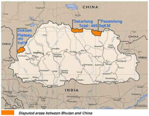
Doklam Standoff. The framework began showing serious structural stress with the Doklam standoff of 2017, when Indian and Chinese troops confronted each other for 73 days on a plateau near the Bhutan-China-India trijunction. India intervened against Chinese road construction that it regarded as a direct threat to the strategic Siliguri Corridor, also called the Chicken’s Neck. The standoff ended without a clear resolution but signalled a new Chinese willingness to test Indian redlines and a meaningfully changed strategic posture.

Galwan Clash. On the night of 15 June 2020, Indian and Chinese soldiers clashed in the Galwan Valley in Eastern Ladakh.  It caused fatalities on the Line of Actual Control in 45 years.  The clash was not a spontaneous skirmish but the violent consequence of Chinese infrastructure construction across multiple friction points in Eastern Ladakh, systematically altering the status quo. Galwan shattered the diplomatic architecture built over three decades and triggered the gravest rupture in India-China relations since 1962.


Insolvability Drivers

The Tibet factor. This factor remains structurally central. India’s fundamental position is that it inherited a valid boundary from its colonial predecessor. The Tibetan government’s legal authority at the time of the Simla Convention had endorsed the Simla Convention. China’s fundamental anxiety is that international legitimisation of the McMahon Line would imply that Tibet possessed the sovereign authority to conclude treaties.

Dispute Asymmetry.  means that the two sides are not exchanging equivalent concessions. China’s primary strategic interest is in Aksai Chin, which it already controls and which is essential for connecting Xinjiang to Tibet via the G219 highway. India’s primary claim is to Arunachal Pradesh, which India already administers. The logical resolution would require India to formally abandon its claim to Aksai Chin and China to formally renounce its claim to Arunachal Pradesh. Neither government has found the domestic political space to make that concession, and no leader on either side has been willing to bear the political cost of being seen as the one who gave territory away.

The Shifting Balance of Power.  This reduces China’s incentive to settle on terms India could accept. In 1988, when the framework of managed competition was established, the two economies were roughly comparable in size. Today, China’s economy is approximately five times larger than India’s, and its military modernisation has outpaced India’s by a significant margin. From Beijing’s perspective, time and the correlation of forces are on its side. Settling now, on terms of rough equivalence, would mean forfeiting the strategic advantages.


Line Awaiting Resolution

The dispute has outlived the Bhai-Bhai idealism, the 1962 war, decades of diplomatic engagement/confrontation, the Cold War, and multiple generations of leaders on both sides. The line that was never agreed upon remains a source of danger, distrust, and unfinished history. It awaits a political moment when leaders are willing to trade the ambiguity of the present for the clarity that resolution alone can provide. That moment is still awaited more than six decades after the war that defined the modern shape of the dispute.


Please Add Value to the write-up with your views on the subject.


1942
Default rating

Please give a thumbs up if you  like The Post?


For regular updates, please register your email here:-

Subscribe


References and credits

To all the online sites and channels.

Pics Courtesy: Internet

Disclaimer:

Information and data included in the blog are for educational & non-commercial purposes only and have been carefully adapted, excerpted, or edited from reliable and accurate sources. All copyrighted material belongs to the respective owners and is provided only for wider dissemination.


References:


Lamb, A. (1964). The China-India border: The origins of the disputed boundaries. Oxford University Press.

Lamb, A. (1973). The Sino-Indian border in Ladakh. Australian National University Press.

Garver, J. W. (2001). Protracted contest: Sino-Indian rivalry in the twentieth century. University of Washington Press.

Garver, J. W. (2011). The unresolved Sino-Indian border dispute: An interpretation. China Report, 47(2), 99–113.

Lintner, B. (2018). China’s India war: Collision course on the roof of the world. Oxford University Press.

Menon, S. (2016). Choices: Inside the making of India’s foreign policy. Brookings Institution Press.

Menon, S. (2021). India and Asian geopolitics: The past, present. Brookings Institution Press.

Raghavan, S. (2010). War and peace in modern India: A strategic history of the Nehru years. Permanent Black.

Hoffmann, S. A. (1990). India and the China crisis. University of California Press.

Shakya, T. (1999). The dragon in the land of snows: A history of modern Tibet since 1947. Columbia University Press.

Goldstein, M. C. (1989). A history of modern Tibet, 1913–1951: The demise of the Lamaist state. University of California Press.

Arpi, C. (2009). 1962 and the McMahon Line saga. Lancer Publishers.

Fravel, M. T. (2020). China’s changing approach to military coercion in territorial disputes. The Washington Quarterly, 42(3), 179–201.

733: DRAGON’S DANCE ON TOP OF THE WORLD’S ROOF


Article published on the “Life Of Soldier” website on 02 Sep 25


Tibet, a land of ancient monasteries, rugged plateaus, and a deeply spiritual culture, has been under Chinese control since the 1950s, with the annexation solidified by 1959. For over six decades, Tibetans have endured what many describe as a systematic erosion of their identity, culture, and autonomy. Yet, the Tibetan people have demonstrated extraordinary resilience, keeping their cause alive through peaceful resistance, global advocacy, and an unwavering belief in the right to self-determination.


Historical Context: A Peaceful Nation Disrupted

Before the Chinese invasion, Tibet functioned as a sovereign entity with its government, army, language, religion, and distinct culture. Governed by Buddhist principles under the spiritual and political leadership of the Dalai Lama, Tibet was a theocratic society where religion was not only a personal belief but the cornerstone of national identity.

In 1950, the People’s Liberation Army entered eastern Tibet under the banner of “liberation.” The Chinese Communist Party (CCP) claimed historical sovereignty over Tibet dating back centuries, a claim widely disputed by Tibetan scholars and leaders. Regardless of the legitimacy of such claims, the fact remains that Tibet was functioning as a self-governing nation when Chinese troops crossed its borders.

In 1951, under immense military pressure, Tibetan representatives were coerced into signing the Seventeen-Point Agreement, which promised autonomy and respect for Tibetan religion and culture in exchange for accepting Chinese sovereignty. Beijing quickly violated many of these terms, accelerating troop deployments, political infiltration, and restrictions on religious practices.

By 1959, tensions reached a breaking point. Thousands of Tibetans gathered around the Norbulingka Palace in Lhasa, fearing that the Chinese military planned to kidnap the Dalai Lama. The protests escalated into a full-fledged uprising. The Chinese responded with overwhelming force, killing tens of thousands. On March 17, 1959, the Dalai Lama fled to India, where he established a government-in-exile in Dharamshala. His departure marked the beginning of mass exile and the scattering of the Tibetan diaspora.


Cultural Erosion: Sinification

China’s policies in Tibet aim to assimilate the region into the broader Han Chinese framework, a process known as Sinification. This is evident in several areas. First, the Tibetan language is marginalised. Mandarin is prioritised in schools, government, and public life, with Tibetan-medium education increasingly restricted. A 2020 Human Rights Watch report noted that Tibetan children are often separated from their families and sent to Mandarin-only boarding schools, disrupting cultural transmission.

Religious repression is another cornerstone of China’s strategy. Tibetan Buddhism, central to the region’s identity, faces severe restrictions. Monasteries are closely monitored, and monks are required to pledge loyalty to the Chinese Communist Party (CCP); images of the Dalai Lama are also banned. The 11th Panchen Lama, Gedhun Choekyi Nyima, recognised by the Dalai Lama in 1995, was abducted by Chinese authorities at age six and has not been seen since. China installed its own Panchen Lama, a move widely rejected by Tibetans.

Demographic changes further threaten Tibetan identity. The Chinese government encourages Han Chinese migration to Tibet, particularly to urban centers like Lhasa. This has shifted population dynamics, with Tibetans becoming minorities in their homeland. A 2015 estimate suggested that Han Chinese make up nearly 40% of Lhasa’s population, diluting Tibetan cultural influence.


The Human Cost

According to the International Campaign for Tibet, thousands of political prisoners are currently detained in Tibet, many of them monks, writers, and ordinary citizens. Reports from organisations like Amnesty International and Freedom House document widespread surveillance, arbitrary detentions, and torture of political prisoners. Tibetans face restrictions on movement, with checkpoints and a “grid management” system monitoring daily life. The CCP’s “social stability” policies have led to the imprisonment of thousands for expressing dissent or practising their religion.

Forced labour programs, similar to those reported in Xinjiang, have emerged in Tibet. A 2020 report by the Jamestown Foundation revealed that over 500,000 Tibetans were coerced into labour training programs, often under military-style supervision, to align them with Chinese economic goals. These programs disrupt traditional nomadic lifestyles and tie Tibetans to state-controlled industries.

Despite the extreme repression, Tibetans have not taken up arms. Their resistance has been rooted in nonviolence, inspired by the teachings of the Dalai Lama. This moral high ground has garnered Tibet worldwide sympathy and support.


Environmental Exploitation

Tibet, known as the “Third Pole” for its vast glaciers, is a critical ecological zone. Its rivers, including the Brahmaputra and Mekong, supply water to billions across Asia. Under Chinese control, Tibet’s environment has been exploited for resource extraction and infrastructure. Large-scale mining and damming projects pose a significant threat to ecosystems and downstream water security. A 2021 study estimated that 80% of Tibet’s glaciers are receding due to climate change and human activity, with Chinese projects exacerbating the damage.

Nomadic Tibetans, who have sustainably managed these lands for centuries, are forcibly relocated to urban centres under the guise of poverty alleviation. This disrupts traditional land stewardship and contributes to environmental degradation. Free Tibet, a UK-based advocacy group, reported in 2023 that over 900,000 nomads have been displaced since 2000, undermining both cultural and ecological balance.


The Case for Self-Determination: Struggle for Justice

The Tibetan cause is not merely about a strip of land in the Himalayas. It is a struggle for the survival of a civilisation, its language, religion, identity, and autonomy. Around the world, Tibetan exiles have established vibrant communities that continue to preserve their culture. The Central Tibetan Administration, based in India, operates like a government-in-waiting, promoting democratic values and advocating for meaningful autonomy rather than complete independence, a shift in strategy designed to garner broader international support.

The principle of self-determination, enshrined in the UN Charter, supports Tibet’s right to decide its future. Tibetans have consistently called for autonomy or independence, as evidenced by the Dalai Lama’s “Middle Way” approach, which seeks genuine autonomy within the People’s Republic of China. Yet, Beijing rejects even this moderate proposal, insisting on total control. The Tibetan government-in-exile, based in Dharamsala, India, continues to advocate for Tibetan rights; however, without international backing, its influence remains limited.

Geopolitically, a free or autonomous Tibet could stabilise the region. China’s control over Tibet gives it strategic leverage over South Asia, particularly India, through border disputes and water control. An autonomous Tibet could serve as a buffer state, reducing tensions. Moreover, supporting Tibetan freedom aligns with democratic values and challenges authoritarian overreach.


Future: A Vision for a Free Tibet

Beijing insists Tibet is now “peaceful, prosperous, and free.” But peace without freedom is silence, and prosperity without culture is hollow. Development projects in Tibet have often benefited Han Chinese migrants more than Tibetans, and infrastructure like the Qinghai-Tibet railway has served to accelerate demographic change and resource extraction.

A free Tibet does not mean reversing history to a pre-1950 state but restoring the right of Tibetans to govern themselves, practice their culture, and protect their environment. The Dalai Lama’s vision of autonomy offers a pragmatic path.

Yet the Tibetan spirit endures. From the high plateau to refugee camps in Nepal and classrooms in New York, young Tibetans are learning their language, studying their history, and carrying forward their people’s story. Technology, despite China’s censorship, offers new avenues for education and solidarity.


Conclusion

Tibet’s struggle is not over. It is not forgotten. It is the story of a people whose homeland was taken, whose religion was attacked, and whose culture was targeted for erasure, yet who refused to respond with hatred. In a world increasingly defined by authoritarianism and apathy, Tibetans offer a model of dignity, nonviolence, and perseverance. Tibet’s struggle serves as a litmus test for the global commitment to human rights and self-determination. If the world allows a culture as vibrant as Tibet’s to be erased, it sets a precedent for other authoritarian regimes to act with impunity. The time to act is now, before Tibet’s identity is entirely subsumed.

Please Add Value to the write-up with your views on the subject.


1942
Default rating

Please give a thumbs up if you  like The Post?


For regular updates, please register your email here:-

Subscribe


Link to the article on the website:-

https://www.lifeofsoldiers.com/2025/09/02/dragons-dance-on-top-of-the-worlds-roof/


References and credits

To all the online sites and channels.

Pics Courtesy: Internet

Disclaimer:

Information and data included in the blog are for educational & non-commercial purposes only and have been carefully adapted, excerpted, or edited from reliable and accurate sources. All copyrighted material belongs to respective owners and is provided only for wider dissemination.


References:-

  1. Free Tibet. Forced Displacement of Tibetan Nomads. Free Tibet, 2023.
  2. Tibetan Centre for Human Rights and Democracy. Self-Immolations in Tibet: A Chronology. TCHRD, 2023.
  3. International Campaign for Tibet. Panchen Lama: The Disappeared Tibetan Child. International Campaign for Tibet, 2021.
  4. World Wide Fund for Nature (WWF). The Third Pole: Understanding Asia’s Water Tower. WWF, 2021.
  5. Human Rights Watch. China’s Bilingual Education Policy in Tibet: Tibetan-Medium Schooling Under Threat. Human Rights Watch, 2020.
  6. The Jamestown Foundation. China’s “Poverty Alleviation” in Tibet: Coercive Labour Programs and the Destruction of Tibetan Rural Livelihoods. Jamestown Foundation, 2020.
  7. Central Tibetan Administration. Tibet Was Never Part of China, but the Middle Way Approach Remains a Viable Solution. Central Tibetan Administration, 2018.
  8. Amnesty International. China: Tibet Autonomous Region: Access Denied. Amnesty International, 2015.
  9. Wong, Edward, and Vanessa Piao. “Tibetans Fight to Salvage Fading Culture in China.” The New York Times, 28 Nov. 2015.
  10. Smith, Warren W., Jr. China’s Tibet?: Autonomy or Assimilation. Rowman & Littlefield, 2008.
  11. Goldstein, Melvyn C. A History of Modern Tibet, Volume 2: The Calm Before the Storm, 1951–1955. University of California Press, 2007.
  12. Shakya, Tsering. The Dragon in the Land of Snows: A History of Modern Tibet Since 1947. Columbia University Press, 1999.


211: China Spoiling Bhutan’s GNP (Gross National Happiness)


Pic Courtesy: IPA Journal 

News – This week China and Bhutan signed a Memorandum of Understanding (MoU) on a Three-Step Roadmap to help speed up long drawn boundary talks.


Bhutan

Bhutan, officially known as the Kingdom of Bhutan is a landlocked country in the Eastern Himalayas. It is bordered by China to the north and India to the south, east and west. Nepal and Bangladesh are located in proximity to Bhutan but do not share a land border. The country has a population of over 754,000 and a territory of 38,394 square km (14,824 sq mi) which ranks 133rd in terms of land area, and 160th in population. Bhutan is a constitutional monarchy with Vajrayana Buddhism as the state religion. Hinduism is the second most dominant religion in Bhutan.


Bhutan’s Priorities


Bhutan has a rich and unique cultural heritage that has largely remained intact because of its isolation from the rest of the world. Bhutanese tradition is deeply steeped in its Buddhist heritage. Because of its largely unspoiled natural environment and cultural heritage, Bhutan has been referred to as The Last Shangri-La.


Bhutan is a country of content people, giving more importance to Gross National Happiness (GNP), rather than GDP. The government’s endeavour is to preserve and sustain the current culture and traditions of the country.


Sino – Bhutan Relations


The Kingdom of Bhutan and the People’s Republic of China do not maintain official diplomatic relations, and their relations are historically tense.


Apart from India, Bhutan is the only country with which China has an unsettled land border and Thimphu is also the only neighbouring country with which Beijing does not have official diplomatic and economic relations.


Tibet factor


Bhutan has had a long and strong cultural, historical, religious and economic connections to Tibet. During the 1959 Tibetan uprising, an estimated 6,000 Tibetans fled to Bhutan and were granted asylum.  Bhutan subsequently closed its border to China, fearing more refugees. With the increase in soldiers on the Chinese side of the Sino-Bhutanese border after the 17-point agreement between the Tibetan government and the central government of the PRC, Bhutan withdrew its representative from Lhasa.


Border Dispute


The PRC shares a contiguous border of about 470 km with Bhutan. Bhutan’s border with Tibet has never been officially recognized, much less demarcated. The Republic of China officially claims parts of Bhutan territory as its own. This territorial claim has been maintained by the People’s Republic of China after the Chinese Communist Party took control of mainland China in the Chinese Civil War.


Areas of Dispute


Pic Courtesy: IDR

The Sino-Bhutanese border dispute has traditionally involved 295 square miles (sq mi) of territory, including 191 sq mi in the Jakurlung and Pasamlung valleys in northern Bhutan and another 104 sq mi in western Bhutan that comprise the areas of Doklam, Sinchulung, Dramana and Shakhatoe.


Pic Courtesy: Tribune

China has recently expanded its territorial claims beyond the disputed regions in northern and western Bhutan. It has added territorial claims in Sakteng area in eastern Bhutan, adjoining the Indian state of Arunachal Pradesh. The disputed territory in northern and western Bhutan is relatively small as compared to the new Chinese claim in eastern Bhutan of about 2,051 miles (11 percent of Bhutan’s total area).


China’s Belligerence


Over the years, the Sino-Bhutanese border dispute has become more complicated, with China escalating its claims and taking forceful steps to change the status quo on the ground.


In addition to expanding its territorial claims, China unilaterally has been changing the status quo on the ground through an array of measures, ranging from sending Tibetan grazers and military patrolling teams into disputed areas to building roads and even military structures in contested territory.


Beijing is following its South China Sea strategy in Bhutan as well i.e. push territorial claims and change the demography by creating settlements and bringing civilian population.


Border Talks


Two countries have been engaged in border talks since 1984. They have held over 24 rounds of boundary talks and 10 rounds of negotiations at the ‘Expert Group’ level, in a bid to resolve the dispute.


Two agreements—one on the guiding principles on the settlement of the boundary issues reached in 1988, and the other on maintaining peace and stability in the China-Bhutan border area reached in 1998, provide the basis of the ongoing negotiations.


The disputed territories have been discussed during the past 24 rounds of border talks and included in a “package deal” dispute resolution proposal that China put to Bhutan in 1996. Under this deal, the PRC offered to renounce its claims to the Pasamlung and Jakarlung valleys in northern Bhutan in return for Thimphu ceding territory in Doklam to Beijing.


India’s Concern


The border dispute between Bhutan and China has repercussions for India.


Doklam Area. Doklam Plateau has strategic significance. The plateau is located on the southeast side of the trijunction area. It is an important area between the Chumbi Valley on Chinese side and Siliguri corridor (Chicken’s neck) on Indian side. Control of this area gives an advantage to the side controlling it.


Sakteng Area. China’s most recent territorial claim in Sakteng is also of strategic value. The area adjoins the Indian state of Arunachal Pradesh, which contains disputed territory between China and India. Tawang, a key bone of contention between India and China in the eastern sector of the Line of Actual Control (LAC), lies to Sakteng’s northeast.


Analysis (Personal Views)


  • Resolution of border dispute with China has a direct bearing on Indian interests.
  • Chinese desire to control Doklam and Sakteng areas could be with India in mind.
  • China earlier tried to exchange northern territories in exchange of territory in Doklam.
  • Sakteng has been added due to interest in Tawang area.
  • China has been earlier offering a package deal including aspects like trade and cultural exchange besides resolution of territorial dispute.
  • Bhutan sees the package deal as an opening of window for Chinese to make inroads into Bhutan.
  • Bhutan is wary of, long term effects of Chinese presence on her culture and values.
  • However, younger generations in Bhutan are willing to experiment on engagement with China.
  • India and Bhutan have a very good relations with each other.
  • The details of contents of the MoU and the three step roadmap are not available in the open domain.
  • India needs to keep a close watch on these developments.
  • India needs to work closely with Bhutan for resolution of territorial dispute on mutually beneficial terms.

After Thought


Bhutan should be made to realise that agreeing to Chinese terms (if they get tempted) would not guarantee China getting off her back. China has been known for demanding more and more.


Suggestions and value additions are most welcome


For regular updates, please register here

Subscribe

References

https://theprint.in/diplomacy/india-wants-bhutan-to-settle-china-border-issue-so-it-can-define-trijunction-area-near-doklam/554740/

https://www.thehindu.com/news/international/bhutan-and-china-sign-mou-for-3-step-roadmap-to-expedite-boundary-talks/article36999596.ece

https://www.ndtv.com/india-news/bhutan-china-boundery-dispute-pact-india-on-bhutan-china-dispute-cautious-response-from-india-as-bhutan-china-ink-border-talks-pact-2575830

https://www.tribuneindia.com/news/nation/bhutan-china-sign-mou-on-boundary-issue-india-wary-324614

https://en.wikipedia.org/wiki/Bhutan

English हिंदी