

Presented my views on the Battle Cry Prog on India Today Channel on 03 Oct 25
On October 2, 2025, Defence Minister Rajnath Singh inaugurated two key infrastructure facilities in the strategic Sir Creek sector. The Tidal Independent Berthing Facility (TIBF) and the Joint Control Centre (JCC). These facilities are designed to enhance integrated coastal operations, improve coordination for coastal security, and enable rapid responses to threats in the disputed estuary area, which separates Gujarat’s Kutch region from Pakistan’s Sindh province. During the ceremony, the defence minister issued a stern warning to Pakistan, accusing Islamabad of expanding military infrastructure near the disputed Sir Creek region and harbouring “ill intentions” despite India’s repeated diplomatic efforts to resolve the border issue. He stated that any “misadventure” or aggression by Pakistan in the area would provoke a “decisive response” strong enough to “change both history and geography,” adding that “one route to Karachi passes through the creek.
Sir Creek. Originally, the Ban Ganga is a 96 km (60-mile) tidal estuary in the uninhabited marshlands of the Indus River Delta on the border between India and Pakistan. The creek flows into the Arabian Sea and separates Gujarat state in India from Sindh province in Pakistan. The creek, a marshy waterway, holds strategic and economic significance due to its proximity to maritime routes and potential offshore resources, such as oil and gas. Its intricate network of tidal channels and mudflats not only complicates patrolling but also makes it vulnerable to smuggling, illegal fishing, and potential terrorist infiltration.
Sir Creek Dispute
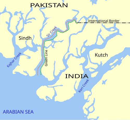
The long-standing India-Pakistan Sir Creek border dispute stems from the demarcation “from the mouth of Sir Creek to the top of Sir Creek, and from the top of Sir Creek eastward to a point on the line designated on the Western Terminus”. From this point onward, the boundary is unambiguously defined as specified in the Tribunal Award of 1968.
Historical perspective
Pre-Partition Era. Sir Creek was part of the princely state of Kutch, under British colonial administration. The region was sparsely populated and primarily marshland, with little attention given to precise boundary demarcation.
1914 Boundary Map. The dispute traces back to a 1914 map by the Bombay Presidency, which showed the creek as part of Kutch. However, the boundary was vaguely defined, with the creek’s eastern bank marked as the border between Kutch and Sindh, both of which were then under British India.
1925 Survey. A subsequent survey in 1925 placed the boundary along the creek’s midline, creating ambiguity as the creek’s channels shifted over time due to tidal and sediment changes.
1947 Partition. After India and Pakistan gained independence, the Rann of Kutch, including Sir Creek, became a contested area. The partition agreement placed Kutch in India and Sindh in Pakistan, but the exact boundary in the creek remained unclear due to inconsistent colonial-era maps.
1956 Dispute. The issue arose when Pakistan claimed the entire creek, arguing that it was part of Sindh, while India maintained that the boundary ran along the creek’s eastern bank, based on pre-1947 maps. This led to minor skirmishes and diplomatic exchanges.
1965 Rann of Kutch Conflict. Tensions escalated in 1965 when Pakistani forces attempted to assert control over parts of the Rann of Kutch, including areas near Sir Creek. This led to the Indo-Pakistani War of 1965, with Indian forces advancing toward Lahore, as noted in Rajnath Singh’s 2025 statement.
1968 Tribunal Award. The Indo-Pakistan Western Boundary Case Tribunal awarded 90% of the Rann of Kutch to India but left the Sir Creek boundary unresolved, as it was not explicitly addressed. The tribunal’s maps suggested the boundary along the creek’s eastern edge, favouring India’s claim, but Pakistan interpreted it differently, asserting the midline as the boundary.
1970s-1980s. The dispute simmered with periodic flare-ups, including naval patrols and minor confrontations in the creek. Both nations maintained differing interpretations of their boundaries, which impacted the maritime boundary demarcation.
1999 Kargil War. While not directly related to Sir Creek, the war heightened distrust, stalling bilateral talks on the dispute.
2000s Negotiations. India and Pakistan held several rounds of talks as part of the Composite Dialogue process, including surveys in 2007 to map the creek. However, disagreements persisted over historical maps and the boundary’s alignment.
2008 Mumbai Attacks. Diplomatic progress halted after the attacks, as India-Pakistan relations deteriorated.
2012-2023. Intermittent discussions and joint surveys failed to resolve the issue. Pakistan’s reported military infrastructure expansion in the region, as mentioned by Rajnath Singh in 2025, reflects ongoing tensions.
Current Status.
The Sir Creek dispute, rooted in vague colonial-era boundaries, has persisted since 1947 due to differing interpretations of maps, strategic interests, and economic stakes. Despite occasional talks and surveys, mutual distrust and geopolitical tensions, as highlighted by recent statements, continue to keep the issue unresolved, with the potential for escalation if either side pursues aggressive actions.
Recent Infrastructure Expansion by Pakistan. As of early October 2025, satellite imagery, intelligence reports, and media analyses indicate Pakistan has significantly expanded its military infrastructure in the Sir Creek sector along the India-Pakistan border, raising concerns about security and strategic maritime control in this contested region. Indian officials have described these developments as indicative of “ill intent” and a potential prelude to aggression amid ongoing border tensions. No official confirmation or denial from Pakistani authorities has been reported. Key Elements of the Infrastructure Expansion include:-
-
- New Roads and Forward Operating Bases. Pakistan has constructed access roads and forward posts to enhance troop mobility in the challenging marshland terrain, including new forward operating bases to support operations.
- Fortifications and Radar Installations. The expansion includes hardened bunkers, surveillance radars, and air defence systems, such as missile networks, to bolster defensive and monitoring capabilities.
- Troop and Asset Deployments. There has been an increased presence of the Pakistan Army, Rangers, and Creek battalions, with plans reportedly aimed at boosting troop strength to brigade-level numbers. Additional assets include coastal defence boats, marine assault crafts, hovercraft, offshore patrol boats, and maritime patrol and surveillance aircraft.
- Infra Supporting Hybrid Operations. The infrastructure supports unconventional tactics, combining drones, speedboats, and infantry, and leveraging the fog-laden marshes and challenging terrain to gain a strategic advantage.
Strategic and Economic Significance
The Sir Creek area holds significant strategic, economic, and geopolitical importance.
Strategic Importance
Maritime Security. Sir Creek’s location near the Arabian Sea makes it critical for naval operations. Control over the creek influences access to maritime routes and monitoring of the India-Pakistan maritime boundary.
Proximity to Karachi. The creek is close to Karachi, Pakistan’s economic hub and a major port. As noted by Defence Minister Rajnath Singh in October 2025, “the road to Karachi also passes through the Creek,” highlighting its strategic value in potential military scenarios.
Posturing. Both nations maintain naval and coast guard presence in the region, with Pakistan reportedly expanding military infrastructure, escalating tensions. Control over Sir Creek strengthens either country’s defensive and offensive capabilities in the area.
Economic Significance
Exclusive Economic Zone (EEZ). The creek’s boundary determines the maritime boundary, affecting the EEZ, which extends 200 nautical miles into the Arabian Sea. A shift in the boundary could alter control over thousands of square kilometer of sea, impacting access to:
Oil and Gas Reserves. The region is believed to have significant offshore hydrocarbon deposits, critical for energy security.
Fisheries. The creek and surrounding waters are rich in marine resources, supporting the livelihoods of coastal communities.
Trade Routes. The creek’s proximity to international shipping lanes makes it vital for maritime trade security, especially for India’s ports in Gujarat, like Kandla and Mundra.
Geopolitical Implications
India-Pakistan Relations. The unresolved Sir Creek dispute, which has been ongoing since 1947, is a flashpoint in bilateral tensions.
Regional Power Dynamics. Control over Sir Creek enhances regional influence.
International Attention. The dispute’s maritime implications draw interest from global players, as it affects energy and trade routes in the Arabian Sea.
New Indian Infrastructure
The Defence Minister inaugurated the Tidal Independent Berthing Facility and the Joint Control Centre in the strategic Creek sector, underlining their role as “key enablers” for integrated coastal operations and rapid threat response. These installations are designed to enhance maritime security by improving inter-agency coordination, facilitating real-time surveillance, and enabling the swift deployment of forces in the event of hostile action or infiltration attempts. By enhancing infrastructure and command capabilities in this sensitive region, India is signalling its resolve to deter cross-border misadventures and ensure maritime dominance along its western frontier.
Tidal Independent Berthing Facility (TIBF)
The Tidal Independent Berthing Facility (TIBF) is a specialised maritime infrastructure developed to enable continuous berthing and operational readiness of patrol vessels, interceptor crafts, and support boats, particularly in tidal and shallow water environments such as the Creek and Sir Creek sectors along India’s western coast. Unlike conventional jetties that are dependent on high tide for docking, the TIBF is engineered to function independently of tidal variations, ensuring round-the-clock operability.
Technical Features.
-
- All-tide Access. Designed to accommodate vessels irrespective of tidal levels, enabling operations in shallow creeks and mudflat areas.
- Reinforced Jetty Structures: Built to withstand tidal currents, siltation, and saline corrosion common in marshland environments.
- Dedicated Berthing Points. Provides secure docking for fast patrol boats, interceptor crafts, and small naval/coast guard vessels.
- Logistics & Maintenance Support. Equipped with refuelling, re-arming, and repair support for extended maritime deployments.
- Integration with Command Facilities. Linked to the Joint Control Centre (JCC) for real-time operational coordination.
Operational Importance
-
- Rapid Deployment. Enables security forces to launch patrols and intercept missions without waiting for favourable tides.
- Enhanced Surveillance. Facilitates continuous maritime presence in sensitive zones prone to infiltration and smuggling.
- Reduced Turnaround Time. Boats can be replenished, repaired, and redeployed locally, thereby avoiding delays associated with distant bases.
- Force Multiplication. Provides a forward operating base.
Joint Control Centre (JCC)
The Joint Control Centre (JCC) in the Creek/Sir Creek sector is a command-and-control hub established to integrate operations of multiple maritime and security agencies in one of India’s most sensitive border zones. It functions as a nerve centre for monitoring, coordinating, and directing responses to security challenges in the tidal creek areas of Gujarat, which are prone to infiltration, smuggling, and hostile cross-border activity.
Technical & Functional Features
-
- Real-time Surveillance Integration. Links coastal radars, electro-optical sensors, and AIS (Automatic Identification System) data. Receives live feeds from unmanned aerial platforms, patrol boats, and shore stations.
- Facilitates Multi-agency Coordination. Connects the Indian Air Force, Navy, Coast Guard, Border Security Force (BSF), and Maritime Police. Provides a single decision-making platform to avoid duplication of efforts.
- Communication & Data Fusion. Equipped with secure communication networks for instant sharing of intelligence. Uses data fusion systems to correlate inputs from different agencies for accurate threat assessment.
- Rapid Response Management. Directs interceptor crafts, patrol vessels, and aerial reconnaissance units for quick deployment. Works in tandem with the Tidal Independent Berthing Facility (TIBF) to enable faster operational turnaround.
Operational Importance.
-
- Unified Command. Eliminates delays caused by inter-agency silos, ensuring faster and more informed decision-making.
- Persistent Monitoring. Provides 24/7 surveillance of the complex tidal creeks and mudflats, which are difficult to patrol physically.
- Threat Neutralisation. Reduces response time against illegal fishing, narcotics trafficking, arms smuggling, and potential terrorist infiltration.
- Resource Optimisation. Allows coordinated deployment of assets, reducing fuel, time, and manpower wastage.
Strategic Significance (TIBF and JCC)
- It provides India with a technological and operational edge in managing this sensitive frontier.
- It complements the National Command, Control, Communication, and Intelligence (NC3I) network.
- It strengthens India’s western seaboard against hybrid threats (terrorism, piracy, and smuggling).
- It demonstrates India’s ability to maintain constant vigilance and deliver swift, decisive responses to misadventures in the sector.
- It improves the reach and endurance of coastal security assets.
- It strengthens India’s ability to dominate and monitor the area.
- It sends a clear message of zero tolerance for cross-border misadventures by enabling faster threat response.
- It enhances the local security ecosystem by improving coordination among the Indian Navy, Coast Guard, Border Security Force (BSF), and Marine Police.
Conclusion
The Joint Control Centre (JCC) in the Creek sector is a critical force multiplier for India’s coastal defence. By combining technology, inter-agency cooperation, and rapid response capabilities, it transforms a difficult-to-patrol tidal frontier into a well-monitored and defended maritime zone. The TIBF is more than a physical docking point—it is a force enabler in India’s western coastal defence strategy. Overcoming the challenges of tidal restrictions ensures permanent operational readiness in a geopolitically sensitive region. Together, they significantly enhance India’s preparedness in one of its most geopolitically sensitive coastal regions. Their operationalisation also reflects India’s commitment to strengthening integrated coastal operations, surveillance, and rapid response capability against both conventional and non-traditional maritime threats.
Please Add Value to the write-up with your views on the subject.
For regular updates, please register your email here:-
References and credits
To all the online sites and channels.
Pics Courtesy: Internet
Disclaimer:
Information and data included in the blog are for educational & non-commercial purposes only and have been carefully adapted, excerpted, or edited from reliable and accurate sources. All copyrighted material belongs to respective owners and is provided only for wider dissemination.
References:–
- Ministry of Defence, Government of India. Press Release: Raksha Mantri Shri Rajnath Singh virtually inaugurates the Tidal Independent Berthing Facility and the Joint Control Centre (JCC) in the strategic Creek sector. New Delhi, 2 Oct. 2025.
- The Times of India, “What is Sir Creek dispute and why Rajnath Singh is warning Islamabad.” Moneycontrol, 3 Oct. 2025.
- Moneycontrol, Misra, Ashutosh. “The Sir Creek Boundary Dispute: A Victim of India-Pakistan Linkage Politics.” Boundary & Security Bulletin, Durham University (IBRU), no. 8.4, 1998.
- Durham University, Sikander, Ahmed Shah. “River Boundary Delimitation and the Resolution of the Sir Creek Dispute between Pakistan and India.” Vermont Law Review.
- “The Sir Creek Dispute: A Case of Compromise Driven by Common Interests.” ResearchGate (paper).
- “Contested Waters: The Maritime Dimension of India-Pakistan Relations.” South Asian Voices.
- “Use Environmental Diplomacy to Resolve the Sir Creek Dispute.” Stimson Center (policy commentary), 2017.
- “No ‘misadventure’ in Sir Creek, Pakistan warned.” The Tribune India, 3 Oct. 2025.