
Q1. What is the new balance of air power in the world today? Are fighter jets still the focus of warfare, or are drones beginning to take their place?
Fighter jets remain the backbone of air power, and that is not about to change. What has changed fundamentally is the ecosystem around them. A modern fighter operates in a networked environment comprising long-range strike weapons, unmanned systems, loitering munitions, airborne tankers, and space-based ISR.
Drones are taking over the missions that are too risky, too repetitive, or too economically unjustifiable to warrant a manned sortie. They are not replacing the manned aircraft.
The prevailing trend favours a combination of manned and unmanned systems. Manned aircraft are focusing on contested, high-end missions that require judgment, adaptability, and versatile payloads. Concurrently, unmanned systems are being employed in persistent, attritable, and mass-effect roles.
The adaptation to this hybrid model is no longer merely a tactical requirement; it has become a strategic necessity.
Q2. Russia’s Su-57 and the US F-35 embody different philosophies — one emphasises air combat, the other network-centric warfare. Whose future will it be?
The Su-57 seems to reflect the traditional Russian emphasis on kinematic performance and super-manoeuvrability.
The F-35 is claimed to be built around sensor fusion and battlespace awareness. It is advertised as capable of detecting, classifying, and engaging the threat at beyond-visual-range distances through a data architecture spanning an entire networked force.
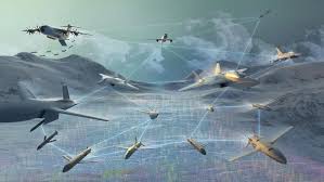
Future aerial combat is progressing towards a network-centric model. Contemporary air engagements are increasingly determined by the priority of achieving information and decision dominance, rather than by performance alone.
Compressing the sensor-to-shooter timeline is now as critical as speed or manoeuvrability. This is fundamentally a problem of decision architecture, not merely of technology.
The sixth-generation programmes are pushing emerging platforms toward multi-domain integration. Fusion of air, space, cyber, and electronic warfare into a single operational architecture will make the network-centric model more definitive.
Q3. China already has the J-20. Has India delayed the AMCA too long, or is it still possible to turn the situation around?
It is a fact that India’s timeline has slipped. The J-20 has been operational for nearly a decade. China is already iterating toward a sixth-generation capability, as evidenced by the prototypes that emerged publicly in late 2024.
AMCA is still working through prototype development. The gap is significant and widening. Reversal of the trend is a realistic necessity.
India can recover lost ground in fighter development if the programme is properly resourced, executed and politically backed.
A significant structural shift is also underway with the Ministry of Defence opening AMCA prototype development to private consortia rather than relying exclusively on the public-sector model.
The window to close the capability gap exists. It will not remain open indefinitely, and the margin for complacency on programme management is close to zero.
Q4. In the wars to come, will Artificial Intelligence and Loyal Wingman drones be more important than pilots?
The pilot does not become less important. His job changes, and in some respects becomes more demanding, not less.
Manned-unmanned combat air teams would have one crewed aircraft effectively commanding a tactical formation of attritable unmanned assets, absorbing risk that would otherwise fall on the manned platform, carrying missiles, jammers, decoys, or forward reconnaissance payloads.
What AI is changing is the speed and volume of decision-making below the human threshold.
AI-enabled satellites and sensors, capable of detecting, classifying, and cueing targets, can push that picture directly to the shooter over tactical data links, rather than routing it back through a ground station first. That is what compressing the sensor-to-shooter timeline. However, human intervention cannot be removed from the kill chain.
As of now, the human crew retains authority over decisions that carry lethal and political consequences, while AI absorbs the burden of processing, prioritising, and routing information faster than any human can.
So, AI and unmanned teaming will unquestionably become more important than they are today. But the human crew would remain relevant and in control.
The pilot of 2040 will be managing a far more complex battle picture, commanding a digital wolfpack rather than flying a single aircraft.
Q5. If India has the opportunity to purchase the F-35 or the Su-57, should we go ahead and purchase them, or stick to developing our own aircraft?
These are not competing choices, and treating them as such leads to a false dilemma.
The IAF’s squadron strength shortfall is real, immediate, and strategically significant. The Rafale has helped close that numerical gap, but has not closed it.
Further, there is a case for qualitative enhancement by the induction of fifth-generation aircraft.
The F-35 carries substantial geopolitical weight, end-use restrictions, and software dependency. Cost, delivery timelines, extended supply chains, Transfer of technology and trust deficit are other factors to be taken into account.
Russia has been a trusted partner, willing to share its technology to a certain extent and accepting Make in India. The Su-57 also raises several concerns besides the factors listed above. India had earlier walked out of the co-development program mainly due to concerns related to cost and technology sharing.
Neither platform offers a clean, dependency-free solution. The importance of self-reliance in defence production is a common lesson emerging from recent wars. The Indigenous program (AMCA) is some time away and urgently needs a technology infusion.
The logical answer is to plug the gap pragmatically by expanding the Rafale order and carefully reassessing the induction of fifth-generation aircraft, while protecting AMCA’s funding and schedule as a non-negotiable national priority.
The near-term interim acquisition and the long-term indigenous programme must be advanced concurrently. The contract should be negotiated in a manner that boosts the indigenous programme rather than undermining it.
Q6. Is engine technology still India’s biggest weakness today?
The answer is YES. The Tejas Mark 1A flies on the American GE F404. AMCA’s initial squadrons will likely depend on an imported engine in the ninety-kilonewton class. The latest news is that negotiations for the GE 414 engine for AMCA have hit rough weather due to a 300 per cent cost increase.
India still does not have a proven indigenous engine anywhere near the ninety to one hundred ten kilonewton range required for a credible fifth or sixth-generation fighter. The Kaveri programme, running since the mid-1980s, is the most visible illustration of how difficult this problem is. High-performance turbofan technology demands a combination of high-temperature metallurgy, single-crystal turbine blade manufacturing, precision tolerances, and decades of iterative test data that very few nations have accumulated.
Urgent need of the hour is a deal that includes a degree of co-production and technology transfer for engine manufacturing in India. Co-production extends the supply chain into India, but it does not give India the ability to independently design, test, and certify a clean-sheet high-thrust engine. Engine independence remains the single weakest link in the self-reliance story.
Q7. Will the export of fighter jets become an increasingly important geopolitical tool?
Fighter exports are already an important geopolitical tool, and their leverage is intensifying rather than diminishing.
Fighter exports create decades of dependency for the buyer. The seller retains influence over the buyer’s operational readiness (by supplying spares, software updates, weapons integration, training pipelines, and maintenance protocols). This dependency lasts for the life of the platform (often 30 to 40 years after the sale).
India’s own indigenous push is a deliberate effort to reduce exposure to precisely this kind of dependency. India’s active promotion of the Tejas and its indigenous missile systems in Southeast Asia, West Africa, and the Gulf reflects a clear understanding that defence exports are as much an instrument of foreign policy as of industrial economics. Future fighter sales will be negotiated as much on reliability of supply and strategic alignment as on cost or raw capability.
Q8. What are India’s greatest achievements and biggest challenges in defence self-reliance?
Tejas moving from a deeply troubled programme to a credible inducted fighter is, to a certain extent, an achievement. The development of indigenous rotary-wing platforms (Dhruv, Rudra, the Light Combat Helicopter Prachand) demonstrates that the industrial capacity extends beyond fast jets. The Astra beyond-visual-range missile and the continued maturation of the BrahMos supersonic cruise missile represent genuine capability in the weapons domain. The missile and space programs are doing comparatively well.
Perhaps most significantly, India’s defence production turnover has grown substantially over the past decade. The country has moved from being almost exclusively an arms importer to a growing exporter, which is a structural shift that would have seemed improbable fifteen years ago.
The challenges are equally tangible. Squadron strength remains well below the sanctioned forty-two. Force multipliers, tankers, airborne early warning and control platforms are inadequate in numbers for a force that needs to project across two frontiers simultaneously. Engine technology remains unresolved.
The achievements prove India can build technically demanding systems. What remains unproven is whether it can build them at the pace and scale that the threat environment now demands.
Q9. How will the Indian Air Force look in 2040, compared to today?
By 2040, assuming the squadron strength target is met or even meaningfully mitigated, the IAF should be a genuinely different force, operating on a different conceptual basis.
AMCA should be in serial production, forming the high-end backbone alongside an upgraded Rafale fleet and a substantially modernised Su-30MKI. The Tejas Mark 2 and the twin-engine deck-based fighter should round out the order of battle, bringing the indigenous content of the combat fleet to a level inconceivable at the beginning of this decade.
Loyal Wingman and unmanned systems would be standard formation elements rather than experimental adjuncts.
AI-assisted Space-based ISR would be integrated into the network.
The UCAV and other Unmanned platforms will significantly enhance airpower capabilities.
If the present trajectory and pace are sustained, by 2040 the IAF should be more networked, more integrated with the space and cyber domains, and far less dependent on foreign supply chains than anything currently in service.
Q10. If you had to identify one defining trend in air warfare over the next twenty years, what would it be?
The shift from platform-centric to weapon-centric airpower operating in a networked environment. The idea that the decisive factor in air combat is increasingly not which aircraft you fly, but how fast you can sense, decide, and act across a distributed force. Ada result:
The sensor-to-shooter timeline will get shortened further.
Space-based satellites with onboard AI capable of detecting, classifying, and cueing the targets will push that picture directly to the shooter.
Manned and unmanned systems will operate as a single collaborative entity rather than parallel fleets.
Mastery of the electromagnetic spectrum, with digital and cognitive dimensions layered on top, would become essential.
Stealth, hypersonics, manoeuvrability, drone swarms, and directed energy technologies/capabilities would follow this shift.
The air forces that adapt to it early will hold the operational advantage in 2040 and beyond. The ones that keep procuring better individual platforms while neglecting the architecture around them (i.e. modern equipment running on an outdated decision framework) will find themselves technologically current but operationally lagging.
Please Add Value to the write-up with your views on the subject.
For regular updates, please register your email here:-
References and credits
To all the online sites and channels.
Pics Courtesy: Internet
Disclaimer:
Information and data included in the blog are for educational & non-commercial purposes only and have been carefully adapted, excerpted, or edited from reliable and accurate sources. All copyrighted material belongs to the respective owners and is provided only for wider dissemination.
