720: INDIA TO ENHANCE HIGH-ALTITUDE SURVEILLANCE WITH ADVANCED MOUNTAIN RADARS


On August 5, 2025, India’s Defence Acquisition Council (DAC), led by Defence Minister Rajnath Singh, approved several critical capital procurement proposals to enhance the Indian Armed Forces’ capabilities. A standout decision was the Acceptance of Necessity (AoN) for advanced mountain radars for the Indian Air Force (IAF). These radars are designed to enhance air surveillance in rugged, high-altitude border regions, addressing operational challenges posed by complex terrain, such as valleys and ridgelines. This move marks a significant step in modernising India’s air defence and surveillance infrastructure, particularly along contested mountainous borders.

With the AoN secured, the following steps include issuing a Request for Proposal (RFP) and finalising contracts. The Defence Acquisition Council’s 2025 approval for additional mountain radars reflects India’s strategic focus on bolstering layered surveillance. These new radars would enhance early warning systems and airspace monitoring, fortifying India’s defence capabilities in strategically sensitive areas.
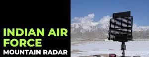
 

Mountain Radars

Mountainous regions present unique challenges for military surveillance and air defence due to uneven terrain, extreme weather conditions, and logistical constraints. Mountain radars, specialised systems designed to overcome these hurdles, are critical for maintaining airspace security in high-altitude environments.

Mountain radars are sophisticated radar systems engineered for dependable operation in rugged, high-altitude terrains. Unlike conventional radar systems, which are generally optimised for flat or coastal regions, mountain radars are specifically tailored to operate effectively within such environments. These systems address challenges related to fragmented lines of sight, severe environmental conditions, and logistical obstacles. Their principal purpose is to detect aircraft, drones, helicopters, and even ground vehicles that may utilise terrain features to evade surveillance, thereby ensuring comprehensive airspace monitoring in difficult terrains.

Mountain radars function on principles analogous to those of traditional radars, emitting electromagnetic pulses and analysing their reflections. Nonetheless, they employ sophisticated algorithms to address terrain-specific challenges. Techniques such as Doppler Filtering are used to differentiate moving targets from static ground clutter. Multi-beam scanning enables the simultaneous tracking of multiple targets, and Clutter Suppression is utilised to eliminate false echoes from rugged landscapes. Operators are provided with real-time updates, including automated alerts for fast-moving or low-flying threats, such as drones or helicopters that may be concealed within valleys.

India’s Mountain Radar Program. The Indian program plays a crucial role in securing its Himalayan borders along the Line of Actual Control (LAC) and Line of Control (LOC). It addresses aerial threats in rugged terrain by deploying advanced radar technology. A key component of this initiative is the DRDO-developed Aslesha Mk I, a three-dimensional, low-level, lightweight radar designed for rapid deployment and ease of transportation. This radar system effectively tracks fighter aircraft, drones, and low-flying helicopters across a range of altitudes, even in complex mountainous environments. Its multi-target tracking capability enhances situational awareness, rendering it an essential asset for the Indian Air Force in continuous border surveillance.  By integrating indigenous systems such as the Aslesha with international technologies, India ensures redundancy and comprehensive coverage, thereby strengthening its defence posture. This program underscores India’s commitment to utilising advanced radar systems to maintain vigilance and respond effectively to emerging threats in the geopolitically sensitive Himalayan region, thereby safeguarding national security.

Core Technologies and Features. Modern mountain radars incorporate cutting-edge technologies to meet operational demands:-

    • 3D Surveillance. Unlike older 2D radars that track only range and direction, systems like the DRDO Aslesha Mk I provide 3D tracking—capturing azimuth, elevation, and range. This is vital for identifying threats at varying altitudes in mountainous regions.
    • Phased-Array Antennas. Using electronically steerable beams, these radars scan rapidly without mechanical movement, enabling quick detection of threats from unpredictable directions.
    • Portability and Modularity. Lightweight and transportable by road, helicopter, or all-terrain vehicles, systems like the Aslesha can be deployed to remote outposts or even airdropped for rapid setup.
    • All-Weather Performance. Robust enclosures and advanced signal processing ensure operation in extreme conditions, filtering out environmental noise like snow or rain.
    • Network Integration. These radars connect to broader air defence networks, combining data from multiple sites to eliminate blind spots caused by terrain and create a comprehensive surveillance picture.

Deployment Strategies.  Effective radar deployment is essential for optimal surveillance and defence. It involves selecting high, accessible sites, such as peaks, for maximum coverage and ease of maintenance. Mobility through portable systems allows quick repositioning against threats, giving an edge over stationary systems. Infrastructure, including generators, batteries, solar panels, and secure satellite or radio links, supports remote operation. Redundancy with overlapping units ensures continuous coverage, thereby reducing risks associated with malfunctions or enemy interference. Following these principles enhances situational awareness, flexibility, and reliability, crucial for modern defence in dynamic, contested environments.

Strategic Significance. Mountain radar systems are essential for defending disputed or poorly defined borders, especially in rugged terrains characterised by’ shadow zones” susceptible to exploitation by adversaries. These systems effectively bridge critical coverage gaps, ensuring that no aircraft or drone remains undetected, even within complex mountainous regions. By providing early warning capabilities, they facilitate prompt responses to aerial incursions, thereby enhancing situational awareness and operational preparedness. Furthermore, mountain radars act as a deterrent against advanced unmanned aerial vehicles (UAVs) and reconnaissance threats, thereby countering potential aggressions. Their incorporation into national air defence frameworks fosters a unified security network, transmitting real-time data to central command for coordinated action. This strategic importance is particularly accentuated in geopolitically sensitive zones, where sustained vigilance is imperative. Through the mitigation of blind spots and the enhancement of defence mechanisms, mountain radars play a crucial role in protecting national sovereignty and ensuring resilient border security within challenging environments.

Challenges. Mountain radars, despite their advanced capabilities, face significant difficulties in deployment and operational effectiveness. Terrain shadows persist as a substantial issue, as rugged landscapes create coverage gaps that low-flying threats, such as drones or stealth aircraft, can exploit. These blind spots require innovative solutions to achieve comprehensive surveillance. Electronic warfare presents another obstacle, with adversaries utilising sophisticated jamming techniques to impair radar functionality, thus demanding robust countermeasures such as frequency hopping and anti-jamming technologies. Furthermore, environmental degradation in harsh mountain climates — characterised by extreme temperatures, snow, and wind — accelerates equipment deterioration, necessitating frequent maintenance and resilient design solutions to sustain operational reliability. These challenges underscore the necessity for ongoing technological advancements and strategic planning to enhance radar effectiveness. Addressing terrain limitations, countering electronic threats, and ensuring durability under extreme conditions are essential for maintaining adequate border security and situational awareness in contested mountainous regions.

Future Trends. The future of mountain radar technology is poised for transformative advancements to enhance border security. Multi-static networks are emerging as a key innovation, utilising multiple transmitters and receivers to eliminate blind spots caused by rugged terrain, ensuring comprehensive coverage. Passive radars represent another leap, leveraging ambient commercial signals—such as TV or cellular broadcasts—for stealthy, energy-efficient detection that is harder for adversaries to jam or detect. UAS integration is also gaining traction, with radars mounted on unmanned aerial systems enabling mobile, adaptive surveillance that can be rapidly repositioned to respond to dynamic threats. These innovations promise greater resilience against electronic warfare, improved detection of low-flying or stealth threats, and enhanced operational flexibility. By integrating these cutting-edge technologies, future mountain radar systems will bolster situational awareness, close coverage gaps, and strengthen defence capabilities in challenging, contested environments, ensuring robust security along geopolitically sensitive borders.

Conclusion

Mountain radars are essential for safeguarding airspace under challenging terrains, integrating advanced electronics, portability, and network connectivity to address contemporary threats. Systems such as the DRDO Aslesha Mk I exemplify this capability, offering India improved surveillance along its mountainous borders. As geopolitical tensions and aerial threats escalate, mountain radars will continue to advance, ensuring robust defence in some of the world’s most challenging environments.


Please Add Value to the write-up with your views on the subject.


1818
Default rating

Please give a thumbs up if you  like The Post?


For regular updates, please register your email here:-

Subscribe


References and credits

To all the online sites and channels.

Pics Courtesy: Internet

Disclaimer:

Information and data included in the blog are for educational & non-commercial purposes only and have been carefully adapted, excerpted, or edited from reliable and accurate sources. All copyrighted material belongs to respective owners and is provided only for wider dissemination.


References: –


  1. Defence Research and Development Organisation (DRDO). Aslesha Mk I 3D Low Level Lightweight Radar Specifications. DRDO Electronics & Radar Development Establishment (LRDE).


  1. Indian Defence Acquisition Council (DAC). 2025 Procurement Approvals for Mountain Radars. Economic Times, India Today, March 2025.


  1. Mishra, S. K., et al. “Design and Development of Lightweight Phased-Array Radars for Mountainous Terrain.” Defence Science Journal, Vol. 68, No. 3, 2018.


  1. Rao, V. K. “Challenges of Radar Deployment in Mountainous Borders.” Journal of Military Technology, 2022.


  1. Thales Group. GO12 Man-Pack Radar Technical Brochure.


  1. Skolnik, M. I. Introduction to Radar Systems, 3rd Edition. McGraw-Hill, 2001.


  1. Mahafza, B. R. Radar Systems Analysis and Design Using MATLAB, 3rd Edition. CRC Press, 2013.


  1. News Reports. “India Boosts Mountain Radar Capabilities.” Economic Times, March 2025; “DRDO’s Aslesha Transforms Border Surveillance.” India Today, February 2025.


698: THE ISTAR TO REDEFINE STRATEGIC SURVEILLANCE FOR THE INDIAN AIR FORCE


My article was published on “The EurasianTimes” website

on 06 Jul 25.


The Indian Air Force (IAF) is set to significantly enhance its surveillance and precision strike capabilities with the procurement of three Intelligence, Surveillance, Target Acquisition, and Reconnaissance (ISTAR) aircraft under a project worth Rs 10,000 crore. The Defence Acquisition Council (DAC), chaired by Defence Minister Rajnath Singh, granted the “Acceptance of Necessity” (AoN) for this initiative on July 3, 2025, as part of a broader Rs 1.05 lakh crore defence modernisation package.

These advanced platforms integrate cutting-edge sensors, communication systems, and artificial intelligence to deliver real-time intelligence, enabling precise battlefield surveillance and strike coordination.  The IAF aims to induct three state-of-the-art ISTAR aircraft, blending global aviation platforms with indigenous sensor technology developed by the Defence Research and Development Organisation (DRDO). The induction would position India among a select group of nations with elite air-to-ground surveillance capabilities.

Understanding ISTAR: A New Class of Airborne Intelligence. ISTAR is not a single system, but an integrated suite of advanced sensors and processing systems mounted on a long-range, high-endurance aircraft. It combines multiple intelligence disciplines, electro-optical, radar, signals intelligence (SIGINT), and electronic intelligence (ELINT), to provide commanders with a comprehensive battlefield picture. Unlike conventional reconnaissance or surveillance aircraft, ISTAR systems go beyond just collecting data. They analyse and fuse it in real-time using AI and advanced analytics, enabling actionable intelligence to be delivered to frontline units and command centers with speed and precision.


The Strategic Imperative for ISTAR

In the rapidly evolving landscape of modern warfare, information superiority is a critical determinant of success. ISTAR aircraft serve as force multipliers by providing real-time intelligence, surveillance, target acquisition, and reconnaissance capabilities. Equipped with advanced sensors, these platforms offer commanders actionable data, enabling precise decision-making in complex battle environments. For the IAF, operating in a volatile geopolitical region marked by ongoing tensions, ISTAR aircraft are indispensable for monitoring enemy movements, tracking high-value targets, and coordinating precision strikes from stand-off ranges.

The urgency for such capabilities was underscored by pivotal events, including the 2019 Balakot airstrike, which highlighted the need for enhanced situational awareness, and the 2020 Chinese aggression along the Line of Actual Control, which exposed gaps in real-time battlefield intelligence. The ISTAR program aligns with India’s broader strategic objectives, including the “Make in India” initiative, which emphasises self-reliance in defence technology. By integrating indigenous sensor systems with globally sourced aircraft platforms, the IAF aims to bolster its operational effectiveness while fostering domestic innovation, positioning India as a formidable player in military aviation.


ISTAR Program

The forthcoming ISTAR project, valued at Rs 10,000 crore, involves acquiring three aircraft from global aviation manufacturers, likely Boeing or Bombardier, which will be fitted with indigenous sensor and electronic systems developed by DRDO’s Centre for Airborne Systems (CABS). These systems, already tested for efficacy, represent a significant leap in India’s defence technology capabilities. The following are relevant aspects of the ISTAR program.

Operational Parameters. The aircraft will operate at a minimum ceiling of 40,000 feet with an endurance of at least eight hours, ensuring sustained surveillance over vast areas. This high-altitude capability allows the platforms to maintain a broad operational footprint.

Sensor Suite. The aircraft will feature:-

    • Synthetic Aperture Radar (SAR) with a range of ≥200 km, enabling high-resolution imaging of ground targets, even through cloud cover or darkness.
    • Ground-Moving Target Indicator (GMTI) with a range of ≥150 km, capable of detecting and tracking moving objects on the battlefield.
    • Electro-Optical/Infrared (EO/IR) Sensors for day/night operations in complex terrains, providing visual and thermal imaging for target identification.
    • Artificial Intelligence and Machine Learning (AI/ML) algorithms for image intelligence, automatic target recognition, and change detection, enhancing the speed and accuracy of data analysis.

Communication Systems. The platforms will be equipped with high-data-rate line-of-sight (LOS) and satellite communication (SATCOM) links, facilitating seamless data sharing with other assets, including satellites, unmanned aerial vehicles (UAVs), and ground-based command centres. This connectivity is critical for integration with the IAF’s Integrated Air Command and Control System (IACCS), enabling real-time coordination across multiple domains.

Ground Segment. The program includes two fixed and four transportable ground exploitation systems for processing and disseminating data, ensuring actionable intelligence reaches commanders swiftly.

Platform. The aircraft are likely to be based on modified commercial jets, such as the Bombardier Global Express or Airbus A319, tailored for military applications. These platforms offer a balance of range, endurance, and payload capacity, making them ideal for ISTAR missions.

The IAF expects delivery within 60 months (five years) from contract signing, with DRDO’s prior testing of sensor systems expediting integration. A 1:32 scale model of the indigenous ISTAR platform, based on a pre-owned Airbus A319, was showcased at Aero India 2023, underscoring India’s commitment to blending global and domestic technologies.


Strategic Significance

The ISTAR aircraft will revolutionise the IAF’s approach to network-centric warfare, enabling real-time, multi-faceted intelligence that enhances precision and reduces collateral damage. By integrating with the IACCS, these platforms will create a cohesive operational picture, coordinating assets across air, ground, and space domains. This capability is particularly critical in India’s regional context, where operations like Operation Sindoor against Pakistan require rapid, calibrated responses without breaching hostile airspace.

Globally, the ISTAR program would position India among an elite group of nations, including the United States, the United Kingdom, and Israel, with advanced air-to-ground surveillance capabilities. The platforms will enhance India’s deterrence posture, providing the ability to monitor and neutralise threats with unparalleled accuracy. The emphasis on indigenous sensor development also aligns with India’s self-reliance goals, reducing dependence on foreign suppliers and positioning the country as a potential exporter of defence technology.


Challenges

Despite its promise, the ISTAR program faces several challenges. Addressing these challenges will be critical to ensuring the program’s success and operational readiness by 2030.

Vulnerability. ISTAR platforms are high-value targets for adversaries. For instance, Indo-Russian BrahMos missile variants are being developed to counter similar enemy platforms, highlighting the need for robust defensive measures, such as electronic countermeasures and stealth features.

Procurement Delays. Past delays due to bureaucratic hurdles and disagreements between the DRDO and the IAF underscore the importance of streamlined processes. The ongoing global tendering for aircraft platforms requires careful vendor selection to ensure compatibility with DRDO systems.

Integration Complexity. Seamlessly integrating indigenous sensors with global platforms demands rigorous testing and validation to avoid operational bottlenecks.

Cybersecurity. The reliance on real-time data sharing necessitates robust cybersecurity protocols to protect against hacking and data breaches.

Human Capital. Operating and maintaining ISTAR systems requires a cadre of highly trained analysts, technicians, and mission planners.


Conclusion

The IAF’s ISTAR aircraft program represents a bold step toward redefining India’s military capabilities in the 21st century. By combining advanced global platforms with cutting-edge indigenous technology, the program addresses urgent operational needs while advancing India’s self-reliance in defence. Expected to be operational by 2030, the three ISTAR aircraft are expected to provide the IAF with unmatched surveillance and strike coordination capabilities, positioning India among an elite group of nations with advanced ISTAR systems. Despite challenges, including procurement delays and platform vulnerabilities, the program’s strategic importance cannot be overstated. As India navigates a complex security landscape, the ISTAR aircraft will serve as a linchpin of its network-centric warfare strategy, ensuring operational superiority and reinforcing its stature as a global military power.


Please Add Value to the write-up with your views on the subject.


1818
Default rating

Please give a thumbs up if you  like The Post?


For regular updates, please register your email here:-

Subscribe


References and credits

To all the online sites and channels.

Pics Courtesy: Internet

Disclaimer:

Information and data included in the blog are for educational & non-commercial purposes only and have been carefully adapted, excerpted, or edited from reliable and accurate sources. All copyrighted material belongs to respective owners and is provided only for wider dissemination.


References: –

  1. Press Trust of India. (2025, June). “IAF’s ISTAR Aircraft Acquisition Gets Nod, Rs 10,000 Crore Project to Boost Surveillance.” The Times of India.
  1. Singh, R., & Sharma, A. (2023). “Aero India 2023: DRDO Showcases Indigenous ISTAR Model.” Defence News India.
  1. Kumar, V. (2024). “India’s Push for Network-Centric Warfare: The Role of ISTAR.” Strategic Analysis Journal, 48(3), 215–230.
  1. Ministry of Defence, Government of India. (2025). Annual Report 2024–25. New Delhi: MoD Publications
  1. Gupta, S. (2021). “Lessons from Balakot: The Need for Advanced Surveillance Platforms.” Indian Defence Review, 36(4), 45–52.
  1. DRDO Newsletter. (2024, August). “CABS Advances Indigenous Sensor Suite for ISTAR Aircraft.” DRDO Publications.
  1. Jane’s Defence Weekly. (2023). “India’s ISTAR Program: Balancing Global Procurement and Indigenous Innovation.”
  1. Bharat Rakshak. (2022). “Evolution of India’s Airborne Surveillance Capabilities.”
  1. Business Today. (2025). Rare global league: ₹10,000 crore I-STAR project to put India in elite club of airborne battlefield intel.
  1. India Defence Analysis. (2024). DRDO’s SCA/ISTAR Aircraft Plans for Indian Air Force.
  1. GlobalSecurity.org. (n.d.). ISTAR – Intelligence, Surveillance, Target Acquisition and Reconnaissance.

425: Launch of 50 Surveillance Satellites


Indian Space Research Organisation (ISRO) chairman has recently announced that India is aiming to launch 50 satellites in the next five years.


These are for geo-intelligence gathering which will include the creation of a layer of satellites in different orbits with a capacity to track the movement of troops and image thousands of kilometers of area.

Gave video inputs to TV 9 (Hindi) on the security aspects.


Please click on the link below:-


Suggestions and value additions are most welcome


For regular updates, please register here:-

Subscribe


References and credits

To all the online sites and channels.


Disclaimer:

Information and data included in the blog are for educational & non-commercial purposes only and have been carefully adapted, excerpted, or edited from sources deemed reliable and accurate. All copyrighted material belongs to respective owners and is provided only for purposes of wider dissemination.

English हिंदी