669: INDIA’S PERSISTENT EYES IN THE SKY: STRATOSPHERIC AIRSHIP PLATFORMS


My article was published on “The EurasianTimes” website

on 05 May 25.


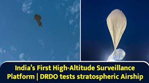
On May 3, 2025, India’s Defence Research and Development Organisation (DRDO) achieved a significant milestone by successfully conducting the maiden flight trial of its Stratospheric Airship Platform at Sheopur, Madhya Pradesh. Developed by the Aerial Delivery Research and Development Establishment (ADRDE) in Agra, the lighter-than-air platform reached an altitude of 17 km, carrying an instrumental payload during a 62-minute flight. The test validated critical systems, including envelope pressure control and emergency deflation mechanisms, with sensor data collected to refine high-fidelity simulation models for future missions. Defence Minister Rajnath Singh and DRDO Chairman Dr. Samir V. Kamat hailed the achievement, emphasising its potential to enhance India’s earth observation, intelligence, surveillance, and reconnaissance (ISR) capabilities. This positions India among a select few nations with indigenous stratospheric airship technology. The successful trial, conducted amid heightened India-Pakistan tensions, underscores DRDO’s focus on advancing high-altitude, long-endurance platforms to bolster national security and surveillance, marking a pivotal step toward operationalising these pseudo-satellite systems.


Stratospheric Airships

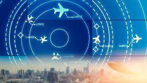
In an era where connectivity, surveillance, and environmental monitoring are paramount, the innovative stratospheric airship platforms, high-altitude, lighter-than-air vehicles operating at 20–30 km, offer a transformative solution. These unmanned, long-endurance systems, often called High-Altitude Platform Systems (HAPS), combine satellites’ endurance with terrestrial systems’ flexibility. Positioned above commercial air traffic and weather systems, they promise to deliver telecommunications, intelligence, surveillance, reconnaissance (ISR), and scientific research at a fraction of the cost of traditional satellites.

Technology. Stratospheric airships are aerostatic vehicles that rely on helium-filled envelopes for buoyancy, allowing them to float in the low-density air of the stratosphere. Unlike fixed-wing HAPS or balloons, airships use propulsion systems, typically electric motors powered by solar panels or hydrogen-based regenerative fuel cells (RFCs), to maintain station-keeping or navigate over specific regions. Their design incorporates lightweight, UV-resistant materials to withstand harsh stratospheric conditions, including temperatures as low as -60°C, intense ultraviolet radiation, and ozone corrosion.

Components. The primary technical challenges include developing lightweight materials, optimising energy efficiency, ensuring thermal management, and achieving reliable control in a near-vacuum environment. These hurdles have historically delayed operational deployment, but recent advancements are closing the gap. Key technological components include:-

    • Envelope and Materials. The helium-filled envelope, often made of advanced composites like polyethene or Mylar, must balance strength, weight, and durability. Innovations in nanotechnology and multi-layered fabrics enhance resistance to environmental degradation.
    •  Power Systems. Solar panels and energy storage (batteries or RFCs) enable continuous operation. RFCs, which generate electricity by combining hydrogen and oxygen, are particularly promising for long-endurance missions, as demonstrated in Japan’s Stratospheric Platform (SPF) program.
    • Payload. Airships carry modular payloads (20–1,500 kg) tailored to specific missions, such as phased-array antennas for 4G/5G connectivity, high-resolution cameras for ISR, or sensors for environmental monitoring.
    • Control Systems. Autonomous navigation and station-keeping require sophisticated algorithms to counter stratospheric winds, which are milder than jet streams but still challenging. Machine learning and real-time data processing are increasingly integrated for precision.


Applications

Stratospheric airships are versatile platforms with applications across civilian, commercial, and military domains. These applications position stratospheric airships as a cost-effective alternative to satellites, with the added benefit of reusability and rapid deployment.

Telecommunications. Airships can provide broadband connectivity to remote or underserved regions, acting as “pseudo-satellites.” For instance, Mira Aerospace’s ApusDuo HAPS delivered 5G connectivity in Rwanda in 2023, demonstrating the potential to bridge the digital divide. Unlike satellites, airships can be repositioned or serviced, offering flexibility for dynamic network demands.

Intelligence, Surveillance, Reconnaissance (ISR). Their ability to loiter over specific areas for extended periods makes airships ideal for ISR.

Environmental Monitoring. Airships with sensors can monitor greenhouse gases, climate patterns, or natural disasters. Sceye Inc., a New Mexico-based company, is developing airships to track environmental changes, supporting global sustainability efforts.

Scientific Research. High-altitude platforms enable ground-breaking scientific research, such as atmospheric studies, astronomy, and other research requiring stable, high-altitude vantage points. NASA’s proposed Centennial Challenge aims to incentivise airship innovations for scientific missions, inspiring a new era of discovery.

Military Applications. Beyond ISR, airships could support GPS jamming, missile defence, wartime communications, electronic warfare and the potential for stealth detection.


Advantages & Limitations

Advantages. Stratospheric airships provide compelling advantages over traditional platforms like satellites. Their cost-effectiveness is a key benefit, with development, launch, and maintenance costs in the millions, far below the billions required for satellites. This affordability democratises access to high-altitude capabilities. Flexibility is another strength; unlike geostationary satellites, airships can be repositioned, serviced, or upgraded to meet evolving mission needs, enabling dynamic applications such as telecommunications or surveillance. Their long endurance—capable of missions lasting months or even years—reduces the need for frequent replacements, enhancing operational efficiency. Additionally, accessibility is improved by operating below orbital altitudes, avoiding the complexities of space debris and stringent international space regulations. These attributes make stratospheric airships an attractive alternative for tasks like broadband delivery, environmental monitoring, and intelligence gathering, offering a versatile, cost-efficient bridge between terrestrial and space-based systems.

Limitations. Stratospheric airship platforms face significant limitations that hinder their widespread adoption. Technical complexity remains a primary challenge, as lightweight materials, efficient energy storage, and precise control systems require further development to ensure reliability in the harsh stratospheric environment. Limited operational systems exacerbate this issue, with most airships still in the prototype phase and scarce real-world flight data to validate performance. Environmental challenges also pose risks, as stratospheric conditions—extreme cold, UV radiation, and ozone exposure—demand robust designs to prevent envelope degradation or thermal failures. Additionally, regulatory hurdles complicate deployment, as coordinating airspace usage and navigating international regulations, particularly for cross-border missions, remains a barrier. These challenges necessitate substantial investment in research, testing, and regulatory frameworks to transition stratospheric airships from experimental to operational systems, unlocking their potential for telecommunications, surveillance, and environmental monitoring.


Development status

The concept of stratospheric airships, pioneered in the 1960s with Raven Aerostar’s High Platform II reaching 70,000 ft in 1969, gained traction in the 1990s as materials and solar technology advanced. Despite high costs and complexity, recent global efforts signal a resurgence, driven by improved designs and commercial potential, as seen in Google’s Loon (2013–2021).

United States. The U.S. pursued stratospheric airships through Lockheed Martin’s High Altitude Airship (HAA) and DARPA’s ISIS for ISR, but both were cancelled due to cost overruns. Aerostar’s HiSentinel reached 74,000 ft in 2005, proving viability. Sceye Inc. now leads the scaling of solar-powered airships in New Mexico for broadband and environmental monitoring, with expansion planned for 2025.

 Japan. Japan’s JAXA launched the Stratospheric Platform (SPF) in the 1990s, focusing on solar-powered airships with regenerative fuel cells. Prototypes were tested, but the program shifted focus by 2009. Japan’s early work on energy systems remains influential for long-endurance HAPS development.

South Korea and Europe. South Korea explored HAPS in the 2000s with limited outcomes. In Europe, Thales Alenia Space’s Stratobus targets ISR and telecom, aiming for five-year missions with a 2023 prototype. The TAO Group’s SkyDragon introduces a segmented design for stability, enhancing European innovation.

 China. China’s Yuanmeng airship, tested in 2015, focuses on military surveillance and stealth detection. Ongoing programs by the Aviation Industry Corporation of China emphasise long-endurance airships for communication and reconnaissance.


Future Prospects

The future of stratospheric airships is bright, driven by technological advancements. Innovations in nanotechnology and composite fabrics will produce lighter, more durable envelopes, extending mission durations. Next-generation regenerative fuel cells (RFCs) and high-efficiency solar cells will ensure reliable power, critical for continuous operation in the stratosphere. Enhanced by machine learning and real-time wind modelling, autonomous control systems will improve station-keeping precision, minimising energy use. These developments will enable airships to loiter for months or years, offering cost-effective alternatives to satellites. By addressing technical challenges, stratospheric airships are poised to revolutionise telecommunications, surveillance, and environmental monitoring by 2030.

Commercialisation and global collaboration are accelerating progress. Companies like Sceye and Stratospheric Platforms are securing investments, reflecting market confidence in high-altitude platform systems (HAPS) for connectivity and monitoring. NASA’s proposed Centennial Challenge could spur international innovation, while public-private partnerships may streamline development. However, scaling production, reducing costs, and validating reliability through extended flight tests remain critical hurdles. If overcome, stratospheric airships could become mainstream solutions, particularly in regions lacking satellite or terrestrial infrastructure, transforming global access to data and security.


Conclusion

Stratospheric airship platforms represent a frontier in high-altitude technology, blending satellites’ endurance with terrestrial systems’ adaptability. From providing broadband in remote areas to enhancing military surveillance and monitoring climate change, their applications are vast and transformative. While historical efforts faced setbacks, recent advancements, such as India’s 2025 test, Sceye’s commercial push, and Thales’ Stratobus, signal a new era of viability. As materials, energy systems, and controls evolve, stratospheric airships are poised to redefine global connectivity, security, and scientific exploration, soaring to new heights in the decades ahead.


Please Add Value to the write-up with your views on the subject.


1275
Default rating

Please give a thumbs up if you  like The Post?


For regular updates, please register your email here:-

Subscribe


References and credits

To all the online sites and channels.

Pics Courtesy: Internet

Disclaimer:

Information and data included in the blog are for educational & non-commercial purposes only and have been carefully adapted, excerpted, or edited from reliable and accurate sources. All copyrighted material belongs to respective owners and is provided only for wider dissemination.


References:-

  1. Aerial Delivery Research and Development Establishment. (2025, May 4). DRDO conducts maiden flight trial of stratospheric airship platform. Press Release, Defence Research and Development Organisation. https://www.drdo.gov.in/press-release/drdo-conducts-maiden-flight-trial-stratospheric-airship-platform
  1. Boucher, R. J. (1985). History of solar-powered airships: From High Platform II to modern HAPS. Journal of Aerospace Engineering, 1(2), 45–56. https://doi.org/10.1061/(ASCE)0893-1321(1985)1:2(45)
  1. Chen, L., & Zhang, H. (2016). Development of the Yuanmeng stratospheric airship for military applications. Chinese Journal of Aeronautics, 29(4), 912–920. https://doi.org/10.1016/j.cja.2016.06.015
  1. Colozza, A., & Dolce, J. L. (2005). High-altitude airship platform systems: Technical challenges and opportunities. NASA Technical Report, NASA/TM-2005-213427. https://ntrs.nasa.gov/citations/20050182976
  1. Japan Aerospace Exploration Agency. (2009). Stratospheric Platform (SPF) program: Final report on solar-powered airship prototypes. JAXA Technical Report, JAXA-RR-09-012. https://www.jaxa.jp/publications/
  1. Mira Aerospace. (2023, August 15). ApusDuo HAPS delivers 5G connectivity in Rwanda. Aerospace Technology News. https://www.aerospacetechnews.com/mira-aerospace-apusduo-5g-rwanda-2023
  1. Sceye Inc. (2024, December 10). Sceye advances stratospheric airship production for broadband and environmental monitoring. Business Wire. https://www.businesswire.com/news/sceye-stratospheric-airship-expansion-2025
  1. Thales Alenia Space. (2023, June 20). Stratobus: Progress toward 2023 prototype for ISR and telecommunications. Thales Group Press Release. https://www.thalesgroup.com/en/stratobus-2023-prototype-update
  1. Tozer, T. C., & Grace, D. (2001). High-altitude platforms for wireless communications. Electronics & Communication Engineering Journal, 13(3), 127–137. https://doi.org/10.1049/ecej:20010303
  1. Yang, Y., & Wu, J. (2018). Advancements in regenerative fuel cells for stratospheric airships. Energy Conversion and Management, 175, 89–98. https://doi.org/10.1016/j.enconman.2018.08.072

668:DIPLOMATIC EARTHQUAKE: SHIMLA AGREEMENT TEETERS ON THE EDGE


My article was published on The EurasianTimes website on 04 May 25.


The Shimla Agreement, signed on July 2, 1972, between India and Pakistan, is a cornerstone of South Asian diplomacy. Forged in the aftermath of the 1971 Indo-Pakistani War, which led to the creation of Bangladesh, the agreement aimed to establish a framework for peaceful bilateral relations and normalise ties between the neighbours. Signed by Indian Prime Minister Indira Gandhi and Pakistani President Zulfikar Ali Bhutto in Shimla, Himachal Pradesh, the treaty sought to end hostilities, resolve disputes peacefully, and lay the groundwork for cooperation.

On April 24, 2025, Pakistan’s National Security Committee (NSC), its top civil-military decision-making body, announced the suspension of the 1972 Shimla Agreement, alongside other bilateral agreements with India, in retaliation for India’s suspension of the Indus Waters Treaty (IWT) on April 23, 2025. This escalation was triggered by the Pahalgam terror attack in Jammu and Kashmir on April 22, 2025, which killed 26 civilians, including two international tourists. The suspension of the Shimla Agreement has thrust it back into the spotlight.

The suspension reignited debates about the Shimla Agreement’s historical significance. In 1972, Indira Gandhi faced criticism from opposition parties, notably the Jan Sangh (predecessor to the BJP), for not converting the ceasefire line into an international border. Atal Bihari Vajpayee, then a prominent opposition leader, protested in Shimla against the agreement, arguing it conceded too much to Pakistan.


The Treaty

The Shimla Agreement emerged from the geopolitical upheaval of the 1971 Indo-Pakistani War. The war was triggered by Pakistan’s brutal suppression of the Bangladesh Liberation Movement in East Pakistan, leading to a humanitarian crisis and the displacement of millions of refugees into India. India’s military intervention, supporting the Mukti Bahini (freedom fighters), resulted in a decisive victory, with the surrender of over 93,000 Pakistani soldiers and the creation of Bangladesh.

The war left Pakistan diplomatically and militarily weakened, necessitating negotiations to address post-war issues such as prisoner repatriation, territorial disputes, and the future of bilateral relations. After intense negotiations, the agreement was signed at Barnes Court (now Raj Bhavan) in Shimla. A key sticking point was the status of Kashmir, with India insisting on bilateralism and Pakistan seeking flexibility to internationalise the issue. Personal diplomacy between Gandhi and Bhutto, including late-night discussions, facilitated a compromise that emphasised peaceful coexistence while sidestepping a definitive resolution on Kashmir.


Provisions of the Shimla Agreement

The concise Shimla Agreement contains six key provisions to foster peace and cooperation. These provisions are rooted in sovereignty, bilateralism, and non-interference.

    • Bilateral Resolution of Disputes. Both nations committed to resolving all disputes, including the Kashmir issue, through peaceful bilateral negotiations, explicitly rejecting third-party mediation, such as from the United Nations. This clause has been a cornerstone of India’s foreign policy, emphasising that Kashmir is a bilateral matter.
    • Establishment of the Line of Control (LoC). The December 17, 1971, ceasefire line was formalised as the Line of Control in Jammu and Kashmir. Both sides agreed to respect the LoC without unilateral alterations, irrespective of their differing legal interpretations. This provision aimed to stabilise the volatile Kashmir region by establishing a de facto boundary.
    • Respect for Sovereignty and Territorial Integrity. India and Pakistan pledged to respect each other’s sovereignty, territorial integrity, and political independence and refrain from interference in internal affairs. This clause sought to prevent destabilising actions, such as supporting insurgencies or hostile propaganda.
    • Non-Use of Force. Both countries agreed to refrain from the threat or use of force against each other’s territorial integrity, aligning with the principles of the United Nations Charter. This provision aimed to de-escalate military tensions and promote peaceful coexistence.
    • Normalisation of Relations. The agreement outlined steps to normalise relations, including resuming communications, trade, cultural exchanges, and people-to-people contacts. It also facilitated the repatriation of prisoners of war and civilians detained during the conflict, marking a humanitarian gesture.
    • Recognition of Bangladesh. While not explicitly stated, the agreement paved the way for Pakistan’s eventual diplomatic recognition of Bangladesh as a sovereign nation, resolving a major point of contention post-1971.

Additionally, the agreement included provisions for future meetings between the heads of government to further peace efforts and address unresolved issues. India returned over 13,000 km² of captured Pakistani territory, demonstrating goodwill.


Relevance of the Shimla Agreement

The Shimla Agreement remains a pivotal reference point in India-Pakistan relations, shaping diplomatic and strategic interactions for over five decades. Its relevance can be assessed across several dimensions:-

Bilateralism as a Diplomatic Framework. India’s foreign policy bedrock has been the emphasis on bilateral dispute resolution. India has consistently cited the agreement to counter Pakistan’s attempts to internationalise the Kashmir issue at forums like the United Nations. The agreement’s rejection of third-party mediation aligns with India’s stance that external involvement, particularly from Cold War superpowers or the UN, complicates rather than resolves bilateral issues.

Stabilisation of the Line of Control. The formalisation of the LoC provided a pragmatic mechanism to manage the Kashmir dispute. Despite frequent ceasefire violations, the LoC remains the de facto boundary, guiding peace talks and ceasefire agreements. Its recognition through decades of practice has given it international legitimacy, even after the agreement’s suspension.

Humanitarian and Diplomatic Aspect.  The agreement facilitated the repatriation of prisoners of war and civilians, addressing immediate post-war humanitarian concerns. It also set the stage for Pakistan’s recognition of Bangladesh, reducing a major source of regional hostility. These outcomes underscored the agreement’s role in de-escalating tensions and fostering dialogue, highlighting its humanitarian and diplomatic achievements.

Challenges to Implementation. Despite its noble intentions, the agreement’s vision of normalised relations has been elusive. Persistent mistrust, cross-border terrorism, and differing interpretations of the Kashmir issue have hindered progress. Pakistan’s attempts to internationalise Kashmir and incidents like the 1999 Kargil War and the 1984 Siachen conflict violated the agreement’s spirit, underscoring its fragility.

 Contemporary Context. The agreement’s relevance has been tested by evolving geopolitical dynamics, including the nuclearisation of both nations’ post-1998 and India’s abrogation of Article 370 in 2019, which revoked Jammu and Kashmir’s special status. Pakistan’s suspension of the agreement in 2025 further questions its efficacy, yet India upholds bilateralism as a guiding principle.


Repercussions of the Suspension

On April 24, 2025, Pakistan announced the suspension of the Shimla Agreement. This move, coupled with the closure of the Wagah border, trade suspension, and airspace restrictions, marks a significant escalation in bilateral tensions. The suspension’s repercussions are multifaceted.

Symbolic and Diplomatic Impact. Pakistan’s suspension is mainly symbolic, as the agreement’s practical relevance has diminished due to repeated violations. The bilateral dialogue mechanism envisioned under the deal has been dormant, with high-level talks suspended after major incidents like the 2019 Pulwama attack. The suspension formalises Pakistan’s shift toward internationalising the Kashmir issue, potentially seeking involvement from the UN, China, or the Organisation of Islamic Cooperation (OIC).

Strategic Implications for the LoC. The suspension raises concerns about the LoC’s status. Pakistan’s non-recognition of the LoC as a de facto border could lead to increased ceasefire violations or attempts to alter the status quo, as seen in past conflicts like Kargil. However, the LoC’s international recognition and India’s military preparedness mitigate immediate tactical consequences.

Regional Stability. The suspension undermines regional stability, particularly in the context of nuclear-armed neighbours. It could escalate diplomatic and military brinkmanship, derailing prospects for dialogue. The closure of cross-border routes and trade further isolates Pakistan economically. At the same time, India’s global diplomatic offensive could weaken Pakistan’s international standing.

Legal and International Perspectives. In international law, the suspension’s impact is limited. The Vienna Convention on the Law of Treaties (VCLT) sets a high bar for treaty termination due to “fundamental changes in circumstances,” and the Shimla Agreement’s “best endeavour clauses” are not strictly binding. The LoC’s status as a de facto border is unlikely to be challenged internationally, and India’s position on bilateralism remains robust. Pakistan’s move may invite criticism for violating international commitments, strengthening India’s narrative of Pakistan’s unreliability.

India’s Strategic Advantage. The suspension paradoxically benefits India by removing diplomatic constraints. India can pursue a harder line against cross-border terrorism, revisit claims over Pakistan-Occupied Kashmir (PoK), and intensify diplomatic efforts to isolate Pakistan. The absence of the agreement may also prompt India to reassess other bilateral treaties, such as visa regimes and trade agreements, aligning them with national security interests.

Challenges and Future Prospects. The Shimla Agreement’s suspension highlights its unfulfilled potential. Deep-seated mistrust, domestic political pressures, and external influences, such as Pakistan’s alignment with China, have consistently undermined its objectives. The lack of a dispute resolution mechanism within the agreement limited its enforceability, and differing interpretations of Kashmir’s status fuelled tensions. Reviving bilateral dialogue will require confidence-building measures, such as ceasefire adherence and counter-terrorism cooperation, though the current diplomatic freeze makes this unlikely.


Conclusion

The Shimla Agreement of 1972 was a bold attempt to reset India-Pakistan relations after a devastating war. Its provisions for bilateralism, the LoC, and peaceful coexistence provided a framework for stability, but its implementation was hampered by mistrust and violations. While the agreement remained a diplomatic touchstone for decades, its suspension in 2025 reflects its diminished practical relevance. The repercussions, while symbolic, open the door to heightened tensions and strategic recalibrations, particularly for India. The suspension, Pakistan’s “strategic mistake”, handed India a diplomatic advantage. India can now justify retaliatory measures, such as surgical strikes or economic sanctions, without being bound by the agreement’s constraints. As South Asia navigates this crisis, the Shimla Agreement serves as both a reminder of peace’s fragility and a lesson in reconciling historical grievances.


Please Add Value to the write-up with your views on the subject.


1275
Default rating

Please give a thumbs up if you  like The Post?


Link to the article on the website:-

Diplomatic Fiasco For Pakistan: Why Suspension Of 1972 Simla Agreement Is An Open Invitation To India To Seize Pak-Occupied Kashmir: OPED

For regular updates, please register your email here:-

Subscribe


References and credits

To all the online sites and channels.

Pics Courtesy: Internet

Disclaimer:

Information and data included in the blog are for educational & non-commercial purposes only and have been carefully adapted, excerpted, or edited from reliable and accurate sources. All copyrighted material belongs to respective owners and is provided only for wider dissemination.


References:-

  1. Simla Agreement, July 2, 1972. Ministry of External Affairs, Government of India.
  1. Bhutto, Zulfikar Ali. “Simla Agreement.” Bhutto.org.
  1. “The Shimla Agreement: Background, Provisions, and Contemporary Relevance.” Sanskriti IAS, April 25, 2025.
  1. “Pakistan Suspends 1972 Simla Agreement: What Is It and What Will Be the Impact on LoC.” The Times of India, April 26, 2025.
  1. “Simla Agreement (1972) | Significance, Provisions, Impact, & Challenges.” Britannica, April 27, 2025.
  1. “Pakistan’s Suspension of Shimla Agreement: A Symbolic Move with Limited Impact.” India Sentinels, April 28, 2025.
  1. “Indus Waters Treaty, Simla Agreement ‘in Abeyance’: What This Means.” The Indian Express, April 26, 2025.
  1. “Shimla Agreement 1972 to 2025: From Peace Treaty to Breakdown.” StudyIQ, April 25, 2025.

Bibliography:-

  1. Ganguly, Sumit. Conflict Unending: India-Pakistan Tensions since 1947. Columbia University Press, 2002.
  1. Schofield, Victoria. Kashmir in Conflict: India, Pakistan and the Unending War. I.B. Tauris, 2010.
  1. Snedden, Christopher. Understanding Kashmir and Kashmiris. Hurst & Company, 2015.
  1. Wirsing, Robert G. India, Pakistan, and the Kashmir Dispute: On Regional Conflict and Its Resolution. St. Martin’s Press, 1994.
  1. “Simla Agreement 1972 for UPSC Exam: Know Main Points of Simla Agreement between India and Pakistan.” Jagran Josh, April 24, 2025.
  1. “What Is the Simla Agreement? Check Key Changes After Suspension.” Jagran Josh, April 25, 2025.
  1. “Explained: What Is India-Pak Simla Agreement and Why It Still Matters.” Business Standard, April 24, 2025.
  1. “Simla Agreement 1972: Why It Was Signed and What Pakistan’s Suspension Means for India.” Business Today, April 24, 2025.

666:GPS INTERFERENCE INCIDENT INVOLVING IAF AIRCRAFT OVER MYANMAR


My article was published in Issue 4 (May 25) of the SP Aviation journal.


On March 28, 2025, a devastating 7.7-magnitude earthquake struck Myanmar, claiming over 3,649 lives and injuring more than 5,000 people. In response, India launched Operation Brahma, a humanitarian assistance and disaster relief (HADR) mission, to deliver critical supplies, medical teams, and rescue personnel to the affected regions. The IAF deployed six military transport aircraft, including C-130J Super Hercules and C-17 Globemaster, to ferry 625 metric tons of aid to cities such as Yangon, Nay Pyi Taw, and Mandalay.


The Incident

The first reported incident of GPS spoofing occurred on March 29, when a C-130J aircraft, carrying 15 tons of relief material from Hindon Airbase to Yangon, experienced navigation anomalies in Myanmar’s airspace. Subsequent flights reported similar issues, with sources indicating that most of the six aircraft involved in the operation encountered GPS spoofing on multiple sorties. After the initial incident, IAF pilots were briefed to anticipate such challenges, enabling them to prepare for and mitigate the risks on subsequent flights.

The IAF later clarified that a Notice to Airmen (NOTAM) issued by Mandalay International Airport highlighted the possibility of degraded GPS availability. The NOTAM warned of potential navigation issues in Myanmar’s airspace, and IAF crews were trained to operate under such conditions. Despite the disruptions, all missions were completed successfully, with no reported accidents or deviations from the planned routes. This underscores the professionalism and preparedness of the IAF pilots, providing reassurance about their capabilities in challenging situations.


GPS Spoofing

GPS spoofing is a form of electronic warfare where false signals are broadcast to deceive a receiver, causing it to calculate an incorrect position. Unlike GPS jamming, which blocks signals entirely, spoofing manipulates data to mislead navigation systems, potentially directing an aircraft off course. The technique exploits the weak signal strength of GPS satellites, which can be overpowered by stronger, fraudulent signals generated from ground-based or airborne platforms. GPS spoofing is increasingly common in conflict zones, where state and non-state actors deploy electronic warfare to disrupt adversaries.

Modern military aircraft, however, are equipped with additional navigation systems, such as INS, which uses gyroscopes and accelerometers to track position independently of external signals. The IAF’s prompt switch to INS ensured safe navigation, but the incident highlighted the vulnerability of GPS-dependent systems in contested environments.


Attributability

Myanmar’s complex political landscape provides critical context for the incident. Since the military coup in 2021, the country has been embroiled in civil conflict, with the junta facing resistance from ethnic insurgent groups and pro-democracy forces. The region is also a geopolitical flashpoint, with major powers like China, India, and the United States vying for influence. China, in particular, has made significant strategic inroads in Myanmar, including infrastructure and military cooperation investments.

Some reports speculated that the spoofing may have been linked to Chinese-enabled systems, given Beijing’s advanced electronic warfare capabilities and presence in the region. The proximity of the interference to the Coco Islands, where China is suspected of developing surveillance and electronic warfare facilities, fueled these suspicions. However, attributing responsibility is difficult due to a lack of definitive evidence.

Other potential actors include non-state militant groups or regional adversaries seeking to cause disruption as a geopolitical signal. Myanmar’s airspace, described as a conflict zone, is particularly susceptible to such interference, with GPS spoofing reported as a common tactic in similar environments globally. Investigating spoofing in foreign airspace is nearly impossible due to limited access and jurisdictional constraints. Myanmar’s junta’s lack of transparency, restricted internet access, and communication controls further complicate any efforts to investigate the incident.


IAF Response and Mitigation

The IAF’s response to the GPS spoofing incidents was swift and effective. The pilots’ training in handling navigation anomalies allowed them to transition seamlessly to INS, ensuring the safe completion of all missions. The pre-emptive NOTAM from Mandalay International Airport also played a crucial role, enabling crews to anticipate and prepare for degraded GPS availability. This response highlights the IAF’s operational resilience in such challenges.

On April 14, the IAF clarified that its crews were well-equipped to operate in environments with compromised GPS signals. The statement avoided directly referencing spoofing, focusing instead on the successful execution of Operation Brahma and the robustness of IAF protocols. This measured response likely aimed to avoid escalating tensions in an already volatile region while highlighting India’s operational resilience.

The incident has sparked discussions within India’s defence establishment about enhancing countermeasures and navigation redundancies. Recommendations include installing real-time interference detection systems, conducting regular audits of navigation vulnerabilities, and advocating for international standards to counter GPS spoofing. The urgent need for global cooperation against electronic warfare is also underscored.


Broader Global Implications

The Myanmar incident is part of a global surge in GPS interference, with similar cases reported near the India-Pakistan border, the Middle East, and Eastern Europe. Spoofing has affected civilian and military aircraft globally, with notable cases like the 2024 Azerbaijan Airlines crash linked to GPS disruption and widespread interference in the Baltic and Black Sea regions.

For military operations, GPS spoofing poses risks beyond navigation errors, including compromised mission security and potential airspace violations. The Myanmar incident underscores the need for robust countermeasures, such as encrypted navigation systems and alternative positioning technologies like Galileo or India’s NavIC. This highlights the importance of preparedness in electronic warfare and the need for robust countermeasures.

Civilian aviation also faces growing risks, as commercial aircraft rely heavily on GPS for navigation, raising concerns about passenger safety. To enhance resilience, the aviation industry is exploring solutions like multi-constellation receivers, which integrate signals from multiple satellite systems, and ground-based navigation aids.

Geopolitically, the incident highlights the challenges of operating in contested regions. It underscores the need for diplomatic efforts to establish international norms against electronic warfare, though enforcement remains difficult in conflict zones.


Lessons Learned and Mitigation Measures

The Myanmar GPS spoofing incident offers several lessons for India and the global aviation community. First, it emphasises the importance of pilot training and redundant navigation systems, which proved critical in averting disaster. Second, it highlights the need for real-time intelligence sharing among allies to map and counter interference trends. Groups like OPSGROUP, which tracks aviation risks, could play a pivotal role in this effort.

Technologically, the incident underscores the urgency of developing spoofing-resistant navigation systems. Advances in quantum positioning, which relies on atomic clocks, and machine learning-based anomaly detection could reduce dependence on vulnerable GPS signals. India’s investment in NavIC, a regional navigation system, offers a potential alternative, though its coverage remains limited compared to GPS.

There is also a case for a global ban on GPS spoofing, similar to existing prohibitions on laser attacks against aircraft. While such measures face resistance from states with advanced electronic warfare programs, they could set a precedent for protecting peaceful humanitarian missions. Regional cooperation, particularly within ASEAN, could also address the region’s airspace vulnerabilities, though political instability poses challenges.


Conclusion

The GPS spoofing of IAF aircraft during Operation Brahma was a stark reminder of modern aviation’s evolving threats. While the IAF’s preparedness ensured the mission’s success, the incident exposed the fragility of GPS-dependent systems in conflict zones. As electronic warfare becomes more sophisticated, nations must invest in resilient technologies, robust training, and international collaboration to safeguard military and civilian operations. The incident reinforces India’s role as a responsible regional power capable of overcoming adversity to deliver aid. Still, it also signals the need for vigilance in an increasingly contested digital landscape.


Please Add Value to the write-up with your views on the subject.

1275
Default rating

Please give a thumbs up if you  like The Post?


For regular updates, please register your email here:-

Subscribe


References and credits

To all the online sites and channels.

Pics Courtesy: Internet

Disclaimer:

Information and data included in the blog are for educational & non-commercial purposes only and have been carefully adapted, excerpted, or edited from reliable and accurate sources. All copyrighted material belongs to respective owners and is provided only for wider dissemination.


References:-

  1. India Today. “Cyber-attack on IAF aircraft involved in Myanmar quake relief op, say defence sources.” April 13, 2025.
  1. The Hindu. “Frequent GPS interference, including ‘spoofing’, near India’s border with Pakistan, Myanmar.” December 28, 2024.
  1. The Print. “Operation Brahma: IAF aircraft flying into earthquake-hit Myanmar faced GPS spoofing.” April 14, 2025.
  1. First post. “Indian Air Force aircraft faced massive cyber attacks in Myanmar airspace during aid mission: Report.” April 13, 2025.
  1. India Sentinels. “What is ‘GPS spoofing’ that the Indian Air Force’s transport aircraft faced in Myanmar airspace?” April 14, 2025.
  1. The Times of India. “IAF jet cyber-attack: IAF jet on Myanmar relief operation faced cyber-attack in the air.” April 14, 2025.
  1. ANI News. “IAF issues clarification on GPS spoofing incident during Myanmar relief operations.” April 14, 2025.
  1. Rediff.com. “IAF jets faced ‘GPS spoofing’ during Myanmar relief mission.” April 13, 2025.
  1. The Economic Times. “IAF planes faced GPS spoofing in Myanmar’s airspace while carrying relief materials for quake victims: Sources.” April 13, 2025.
  1. Mathrubhumi English. “IAF aircraft face GPS spoofing over Myanmar during quake relief mission.” April 13, 2025.
  1. Eurasian Times. “U.S.-Supplied C-130J, C-17 Come ‘Under Attack’ Over Myanmar; What Happened With IAF Aircraft?” April 14, 2025.
English हिंदी