
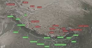
China has been expanding its aviation infrastructure near the India-China border, constructing new airfields in strategic locations. These airfields are primarily located in the Tibet Autonomous Region (TAR) and Xinjiang Uyghur Autonomous Region (XUAR), with strategic significance due to their proximity to sensitive border areas, including India, Nepal, and Pakistan-occupied Kashmir (PoK).
Detailed overview of the new Chinese airfields at Tingri, Lhunze, Burang, Yutian, and Yarkantir (based on available open source information) is as follows:-
- Shigatse Tingri Airport (Tingri, Tibet)
-
- Location: Tingri County, Shigatse Prefecture, Tibet Autonomous Region, China.
- Opened: December 24, 2022
-
- Type: Dual-use (civilian and military)
- Elevation: Approximately 4,300 meters (14,108 feet) above sea level.
- Runway: 4,500 meters
- Proximity to India: Approximately 60 km from the Indian border
-
- Infra: Supports dual-use (military and civilian) operations, potentially for troop deployment and logistics near the Line of Actual Control (LAC) with India. Designed to handle high-altitude operations, likely with a runway suitable for small to medium aircraft and helicopters.
-
- Strategic Significance: Supports China’s broader strategy to bolster infrastructure near disputed borders. Located across the Himalayas from Kathmandu, Nepal, and near the Indian border. Part of China’s “3+1” airport construction plan aimed to boost air connectivity in the region, enhancing civilian access and military logistics near the Line of Actual Control (LAC). Fills a gap between Burang (west) and Shigatse (east), enhancing China’s military and civilian aviation network in southern Tibet.
- Lhunze Airport/Shannan Longzi Airport(Lhunze County, Tibet).
-
- Location: Longzi County, Shannan (Lhokha) Prefecture, Tibet Autonomous Region, China.
- Elevation: 3,980 meters (13,060 feet) above sea level.
- Features a 4,500-meter (14,800-foot) Class 4C runway with seven parking stands.
- Operational since January 12, 2023, following construction that began in April 2021.
- Type: Planned as a dual-use facility.
- Designed to handle 180,000 passengers annually by 2030.
- Equipped for high-altitude operations, likely supporting fighter jets and transport aircraft.
- Proximity to India: Close to Arunachal Pradesh, India
-
- Strategic Significance: Dual-use military and civilian airport, enhancing China’s ability to project power near the LAC. Aims to improve connectivity in remote border areas, facilitating civilian travel and military operations. Located approximately 45 km from the disputed border with Arunachal Pradesh, India, and opposite the Upper Subansiri district. Lhunze’s airfield strengthens China’s military presence in a contested region, with the potential to support operations against India. Part of a broader network of airfields and SAM (surface-to-air missile) emplacements near Arunachal Pradesh.
- Ngari Burang Airport/ Ali Pulan Airport (Burang County, Tibet)
-
- Location: Burang County, Ngari Prefecture, Tibet Autonomous Region, China.
- Opened: December 27, 2023
- Type: Dual-use (civilian and military)
-
- Elevation: 4,250 meters (13,940 feet) above sea level.
- Runway: 4,500 meters.
- Status: Operational since December 27, 2023, with construction approved in April 2021.
- Designed for 150,000 passengers and 600 tons of cargo annually.
- Runway and facilities support dual-use operations, including military aircraft and helicopters.
- Proximity to India: Near the India-Tibet-Nepal tri-junction.
-
- Strategic Significance: It enhances China’s ability to project power and provide logistical support in the western sector of the LAC. It is located near the trijunction of Tibet, Nepal, and India’s Uttarakhand state, approximately 400 km from New Delhi. It is positioned close to Mount Kailash and Lake Manasarovar and is touted as a feeder strip for pilgrims, but has clear military applications. It supports the Ngari-Gunsa airfield, located 220 km away, and enhances China’s control over the southwestern border.
- Yutian Wanfang Airport (Yutian County, Xinjiang)
-
- Location: Yutian County, Hotan Prefecture, Xinjiang Uyghur Autonomous Region, China.
- Elevation: Approximately 1,400 meters (4,600 feet) above sea level (lower than Tibetan airfields).
- Runway: 3,200 meters, capable of handling medium-sized commercial and military transport aircraft.
- Opened: December 26, 2020
- Type: Primarily a civilian airport but with potential dual-use capabilities.
-
- Annual Capacity: Designed to handle 180,000 passengers and 400 tons of cargo
-
- Strategic Significance: This will improve connectivity in southern Xinjiang, which is strategically important due to its proximity to the western sector of the LAC. Situated in south Xinjiang, between Hotan and Qiemo airbases, along the Karakoram Highway. Enhances connectivity in Xinjiang, supporting China’s Belt and Road Initiative and military logistics near the borders with Pakistan and India. Strategically located near the Aksai Chin region, a disputed area with India. Yutian’s airfield supports China’s control over Xinjiang and its borders with India and Pakistan-occupied Kashmir. Likely used for surveillance and logistics, given its proximity to sensitive regions.
- Yarkantir/Yarkant/ShacheAirport (Xinjiang)
-
- Location: Likely refers to Shache (Yarkant) County, Kashgar Prefecture, Xinjiang Uyghur Autonomous Region, China.
- Elevation: Approximately 1,200–1,500 meters (3,900–4,900 feet) above sea level.
- Shache Airport has a runway suitable for small to medium aircraft, with facilities for civilian and potential military use.
- Status: Specific details about a new airfield in Yarkand are limited. However, the region has seen infrastructure enhancements, including upgrades to airbases like Hotan, approximately 240 km from the LAC.
-
- Strategic Significance: Shache Airport (IATA: QSZ, ICAO: ZWSC) is an existing dual-use airport in Yarkant County. It is operational for civilian flights but has military potential. Located in a restive part of Xinjiang, near the Tajik Autonomous County and the Wakhan Corridor, it is close to Pakistan-occupied Kashmir and Afghanistan. It supports China’s internal security operations in Xinjiang and external defence along its western borders. Enhances China’s ability to project power in Central Asia and monitor borders with Pakistan, Afghanistan, and Tajikistan. Part of a broader network of airfields in Xinjiang, including Tashkurgan, which is under construction and strategically located near PoK.
Chinese Aviation Infrastructure Strategy.
Regional Strategy. The airfields in Tingri, Lhunze, and Burang are part of China’s efforts to strengthen its military presence along the LAC with India, particularly after the 2020 Galwan clash. Yutian and Shache (Yarkant) airfields support China’s control over Xinjiang, securing its western borders and facilitating connectivity with Central Asia.
Chinese Narrative. Official Chinese sources often frame these airfields as civilian projects to boost tourism (e.g., Burang for Mount Kailash pilgrims) or regional development. However, their proximity to sensitive borders and dual-use capabilities suggests a primary military purpose, which is downplayed in state media.
Geopolitical Implications. These airfields enhance China’s ability to rapidly deploy troops, conduct surveillance, and support air operations in contested regions, posing a challenge to India, Nepal, and other neighbours.
Inputs to the Queries on Chinese Bases
(Based on the open sources on the net)
Q1. As reflected in the imagery, does the construction and upgrade of new Chinese airbases represent a serious threat to India?
The construction and upgrade of Chinese airbases in Tibet and adjacent areas do represent a serious strategic threat to India, mainly when analysed in the context of recent geopolitical tensions, evolving Chinese military capabilities, and infrastructural patterns since the 2020 Galwan clashes.
Airbases like Tingri, Lhunze, and Burang are located close to the Line of Actual Control (LAC), within 50–150 km. This proximity allows for the quick deployment of PLA Air Force (PLAAF) assets to forward positions and shorter response times in case of a border escalation. These airfields enable coverage of Indian positions in Arunachal Pradesh, Sikkim, Uttarakhand, and Ladakh.
Upgrades to dual-use airfields include extended and hardened runways to support heavier fighters and transport aircraft, and new hardened aircraft shelters (HAS) to protect valuable assets. Advanced radar stations and SAM sites will provide protection. Fuel and ammunition storage facilities reflect a long-term war readiness. These changes reflect a move from rudimentary forward airstrips to permanent, fully capable air combat hubs.
These bases offer greater depth, logistics, and density. The PLAAF can now rotate fighter squadrons and drones rapidly into forward bases.
The network of airbases (e.g., Burang supporting Ngari Gunsa, Tingri filling gaps between Shigatse and Burang) creates strike capability, mutual support, and redundancy.
Bases like Burang (near Nepal) and Tingri (near Bhutan) could pressure India’s neighbours, complicating India’s regional influence. The proximity to the Siliguri Corridor amplifies strategic risks.
Bases like Yutian and Yarkantir in Xinjiang would complement Western Theater Command operations and are positioned to project power toward India. This reflects China’s “strategic envelopment” doctrine, which increases pressure on India along a much broader front.
These Chinese airbases’ construction and systematic upgrading represent a serious and growing threat to India’s strategic posture, particularly by reducing warning time, enabling force concentration, and improving the PLA’s offensive and defensive air operations.
While it does not signal imminent war, it tilts the regional balance and compels India to accelerate military infrastructure development, deepen surveillance, and maintain credible deterrence across the Himalayas.
Q2. Do these new airbases and the consolidation and upgrade of existing ones in Tibet substantially balance out the IAF’s traditional advantage along the India-China frontier?
China’s construction of new airbases and the systematic upgrading of existing ones in Tibet and Xinjiang significantly narrows down, though not entirely erases, the traditional airpower advantage long held by the Indian Air Force (IAF) along the India-China frontier.
The establishment/modernisation of Tingri, Lhunze, Burang (near central and eastern sectors) and Yutian, Yarkantir (in Xinjiang) allows PLAAF aircraft to deploy closer to the LAC, reducing response time and extending their ability to hold Indian targets at risk.
While Tibet’s altitude still limits PLAAF aircraft (lower payloads, reduced engine efficiency), China is trying to mitigate this with more powerful engines and heavy reliance on drones, loitering munitions, airborne early warning aircraft (KJ-500), tankers, and ECM assets based in the rear (e.g., Hotan) but linked with forward bases.
China’s concept of “airbase clusters” means that even if one is targeted (say Lhasa-Gonggar), others nearby (e.g., Shigatse, Pangta) can support operations, enhancing tactical flexibility, survivability, and redundancy.
China’s new and upgraded airbases improve PLAAF’s forward reach, resilience, and responsiveness, mitigating the payload disadvantage of high-altitude operations. Bases like Lhunze and Tingri challenge the IAF’s dominance in the eastern LAC sector by enabling faster, more credible PLAAF operations.
While the IAF continues to enjoy certain operational advantages, China’s new airbases and upgrades in Tibet now provide the PLAAF with a more credible and resilient offensive and defensive posture along the LAC. The earlier asymmetry that favoured India is now more balanced, especially in terms of response time, reach, and multi-layered defences.
Q3. Does the construction of the Burang airbase represent a new and specific threat to airspace over Uttarakhand?
The central sector of the Line of Actual Control (LAC) has historically seen less militarisation compared to the eastern and western sectors (partly due to the rugged terrain and lower perceived threat).
However, the construction of the Burang airbase represents a new and specific potential threat to Uttarakhand’s airspace due to its proximity to the LAC (~60 km), ability to host fighters and drones, and support from nearby SAM systems.
It enhances China’s surveillance, deterrence, and limited power projection over Pithoragarh and Chamoli, particularly near the Lipulekh Pass and Barahoti.
Burang is located near the tri-junction of India, Nepal, and Tibet, directly facing India’s Uttarakhand sector, especially Barahoti, which has witnessed Chinese transgressions in recent years.
The base is less than 100 km from the Indian border, giving PLAAF aircraft and drones a very short flight time to Indian airspace, especially toward sensitive regions like Joshimath, Dharchula, the Kailash-Mansarovar route, and the central Sector’s critical valleys and passes (e.g., Lipulekh, Niti, Mana).
Establishing a permanent airbase at Burang shifts that balance, opening up the possibility of tactical surprise or probing manoeuvres and providing quick-reaction air support for PLA ground units, surveillance, and drones. Deploying long-range air Defence systems could threaten IAF aircraft operating from bases like Bareilly or Gorakhpur.
While the altitude (4250 mtrs) limits the payload of fighters at Burang (as with other Tibetan airbases), the proximity compensates by enabling shorter-range missions with lighter payloads, persistent ISR coverage through drones, and strike options with long-range PGMs even from short-runway-capable aircraft.
Burang can also serve as a forward operating base (FOB) or logistics/surveillance hub, rotating aircraft from rear bases like Shigatse or Lhasa.
This airfield increases airspace monitoring pressure on India, especially as it tries to improve the region’s border infrastructure and patrol routes.
It also forces India to extend air defence coverage into the central sector, possibly stretching resources from already active eastern and western sectors.
Please Add Value to the write-up with your views on the subject.
For regular updates, please register your email here:-
References and credits
To all the online sites and channels.
Pics Courtesy: Internet
Disclaimer:
Information and data included in the blog are for educational & non-commercial purposes only and have been carefully adapted, excerpted, or edited from reliable and accurate sources. All copyrighted material belongs to respective owners and is provided only for wider dissemination.
References:-
- Lin, Christina. “China’s Strategic Airfields and the BRI: The New Logistics Backbone”, Asia Times / Comparative Strategy, 2023.
- Chellaney, Brahma. “China’s Infrastructure Strategy in Tibet and the Implications for India”, Indian Defence Review, 2022.
- Centre for Strategic and International Studies (CSIS), Report example: “PLA Air Force Operations in Tibet and Xinjiang”.
- Institute for Defence Studies and Analyses (IDSA), New Delhi, Reports on border infrastructure and PLA’s posture across the LAC.
- South China Morning Post (SCMP), Occasional reporting on PLA activities and airport developments in Tibet/Xinjiang.
- India Today / ANI / Times Now, Reports on satellite imagery and Indian assessments of Chinese activity post-Galwan.
- Air Power Asia, an Indian think tank with detailed airbase and aerial warfare assessments.
- Military Balance 2024, by the International Institute for Strategic Studies (IISS), Technical information on PLAAF deployment capacities and base hierarchy.
- Civil Aviation Administration of China (CAAC), official press releases on new airports and infrastructure development in Tibet and Xinjiang.