Myanmar’s military junta has conducted the long-awaited elections. This is the first general election since the military seized power in February 2021. The multi-phase ballot is intended to pave the way for a new civilian administration in 2026. However, domestic opponents and international observers have dismissed the exercise as a political façade. They feel it is designed to legitimise continued military rule rather than restore democracy.
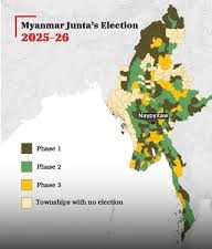
Background. The military overthrew the elected government led by Aung San Suu Kyi on 1 February 2021. The coup triggered mass protests and a nationwide civil disobedience movement. Thousands were killed, and millions were displaced in the following crackdown. The military junta finally announced a staggered three-phase election following repeated postponements. The ballot covers only 265 of Myanmar’s 330 townships. It excludes areas largely under the control of resistance forces. This selective polling undermines any claim to a representative mandate.
Three-Phase Election. Phase one of the election took place on Dec. 28 in 102 townships. The second phase of voting took place on 11 January 2026 in around 100 townships (across Sagaing, Mandalay, Tanintharyi, Shan, Kachin, Kayah and Kayin states). The final phase was concluded in 63 townships across the country on 25 Jan. The junta claimed that turnout was about 52-55 per cent. Opposition groups and civil society organisations dispute this figure. According to them, the participation was low because many voters feared violence or coercion. Human rights groups have highlighted the impact of the junta’s new “Election Protection Law,” which criminalises criticism of the polls with penalties ranging from three years to life imprisonment. More than 300 people have reportedly been arrested for comments deemed hostile to the vote, reinforcing claims that participation has been driven by fear rather than political choice.
Fixed Results. Preliminary count shows a sweeping victory for the Union Solidarity and Development Party (USDP). This is a military-aligned party dominated by retired generals and former military officials. According to reported figures, the USDP has secured 232 of 263 contested seats in the Pyithu Hluttaw (lower house) and 109 of 157 announced seats in the Amyotha Hluttaw (upper house). Smaller ethnic parties have captured a handful of constituencies, but only six parties contested nationwide out of the 57 formally registered. The opposition National League for Democracy (NLD) was dissolved as it refused to re-register under restrictive new party laws. Aung San Suu Kyi remains imprisoned under politically motivated sentences. Myanmar’s 2008 constitution reserves 25 per cent of parliamentary seats for serving military officers. This strengthens the military hold. Combined with USDP victories, this arrangement gives the junta and its proxies a dominant supermajority regardless of popular support.
Legitimacy Challenged. Domestic opposition groups and international organisations have denounced the polls as neither free nor fair. The United Nations has warned that elections held amid mass arrests, censorship and the exclusion of millions of voters cannot be considered credible. UN human rights experts have described the process as an attempt to “manufacture legitimacy” for military rule. Human Rights Watch has called the ballot a “fraudulent claim for credibility,” citing voter intimidation, the absence of independent monitoring and the disenfranchisement of more than six million people living in conflict zones. The International Crisis Group has noted that the USDP benefits from structural advantages created by bans on rivals and by emergency laws that suppress dissent. Western governments, including members of the European Union, have said they will not recognise any administration formed through what they regard as a sham process. ASEAN, the regional bloc of which Myanmar is a member, has declined to send official observers.
Regional Reactions. Regional responses have not been that critical. China and Russia have sent observers to the polls. They prefer stability over political reform. For neighbouring Thailand, Bangladesh and India, the continuation of conflict raises fears of renewed refugee surges and cross-border instability. India has adopted a cautious approach, reiterating its support for a democratic transition. At the same time, it is engaging with the junta to address border security, refugee flows, and concerns over Chinese influence.
What Next. Under the junta’s roadmap, the newly elected parliament is due to convene in March 2026 to choose a president. The new government is expected to take office in April. Senior General Min Aung Hlaing has already passed legislation creating a consultative body that would allow him to retain influence even after a formal handover to a civilian cabinet. Analysts are sceptical that these steps will reduce violence. Resistance forces, including the PDFs and various ethnic armed organisations, are believed to control or contest large parts of the countryside and have vowed to continue fighting what they view as an illegitimate regime.
Analytical View. The elections may internally legitimise the junta’s claim to national coverage. It does not change international perceptions. The process lacks the core ingredients of a genuine democratic transition. This is because of the exclusion of major opposition parties, disenfranchisement of millions of citizens, and participation shaped by fear. The polls do not seem to resolve Myanmar’s political crisis. They appear to formalise a divided reality: a military-controlled political center with a resistant periphery. Post-elections, the hope of a return to civilian rule remains remote. The election symbolises the depth of derailment of Myanmar’s democratic experiment.
Please Add Value to the write-up with your views on the subject.
For regular updates, please register your email here:-
Information and data included in the blog are for educational & non-commercial purposes only and have been carefully adapted, excerpted, or edited from reliable and accurate sources. All copyrighted material belongs to respective owners and is provided only for wider dissemination.
My Article published on the “Indus International Research Foundation” website on 18 Jul 25.
In the grand theater of global geopolitics, alliances and rivalries shape the dynamics of diplomacy. Over the past decade, Turkey under President Recep Tayyip Erdoğan has pursued an increasingly assertive foreign policy that extends well beyond its traditional spheres of influence. One of the most intriguing and consequential elements of this strategy is Turkey’s deepening engagement with India’s neighbours. Turkey’s relations with India’s immediate neighbours form a complex web of strategic, military, economic, and ideological engagements. Turkey has pursued a neo-Ottoman foreign policy, leveraging historical ties, Islamic solidarity, and defence exports to expand its influence in South Asia. This “strategic tango” has significant implications for South Asia’s balance of power, particularly from New Delhi’s perspective.
Turkey and Pakistan: Ideological Brotherhood beyond Diplomacy
The relationship between Turkey and Pakistan is characterised by its closeness and growing complexity, grounded in a shared Islamic identity, historical connections, and reciprocal geopolitical backing. Under the leadership of Erdoğan, these ties have developed into a strong strategic partnership.
The two nations have engaged in collaboration concerning military training, defence manufacturing, and joint naval exercises. Turkey ranks as Pakistan’s second-largest arms supplier, following China, providing sophisticated military equipment, including Bayraktar TB2 and Asisguard Songar drones, corvettes, missile systems, and enhancements for Pakistan’s F-16 fleet. These exports have strengthened Pakistan’s military capabilities, notably in drone warfare, which constitutes an increasing concern for India along the Line of Control (LoC) and other unstable border regions. During the recent India-Pakistan conflict (Operation Sindoor), reports suggest Turkey supplied Pakistan with between 300 and 400 drones, along with other military assistance, thereby intensifying tensions.
Turkey has also supported Pakistan’s stance on Kashmir, frequently raising the issue at the United Nations and other international forums. Ankara has consistently condemned India’s 2019 abrogation of Article 370, which nullified the special status of Jammu and Kashmir, and has articulated this position at various international platforms, including the United Nations. Conversely, Pakistan endorses Turkey on issues such as the Cyprus dispute and Azerbaijan’s stance in the Nagorno-Karabakh conflict, thereby reinforcing their strategic alliance.
By clearly aligning with Pakistan on a sensitive bilateral matter, Turkey has indicated its readiness to confront India on the international stage. This has led to a strong Indian reaction, with tourism bookings to Turkey decreasing by 60% and cancellations increasing by 250% in 2025, along with calls for trade boycotts.
Bangladesh: Growing Engagement and Deepening Ties.
Turkey’s diplomatic relations with Bangladesh have markedly strengthened, primarily due to defence collaboration and economic prospects. Ankara has employed a strategic approach incorporating humanitarian assistance, cultural diplomacy, and religious outreach to foster rapport with Dhaka. The Turkish Cooperation and Coordination Agency (TIKA) has been actively engaged in Bangladesh, financing educational institutions, healthcare facilities, and infrastructure developments. Furthermore, the administration of President Erdoğan has adopted a firm stance regarding the Rohingya crisis, providing refuge to displaced persons and vocally criticising Myanmar’s policies. This stance aligns closely with the perspectives held by Bangladesh.
Bangladesh has reportedly acquired Turkish Bayraktar TB2 drones. These drones, whilst augmenting Bangladesh’s military capabilities, evoke concerns in India regarding their possible deployment along the shared 4,096-kilometre border. Economically, Turkey has actively engaged with Bangladesh through trade and infrastructure initiatives, capitalising on Dhaka’s expanding economy and strategic positioning. Turkey’s neo-Ottoman ambitions align with certain political factions within Bangladesh, notably those sympathetic to Islamist rhetoric, thereby further fortifying bilateral relations.
This ideological alignment, coupled with defence cooperation, has raised concerns in New Delhi, which fears that Turkey’s influence could destabilise its eastern neighbourhood.
Emerging Engagements With Other Neighbours
Turkey has also expanded its focus to smaller South Asian nations, including Nepal, Sri Lanka, Bhutan, Myanmar, and the Maldives. These countries, often overlooked in global strategic considerations, possess significant geopolitical importance due to their strategic locations and vulnerability to external influences.
In Nepal, Turkey’s influence is predominantly diplomatic and cultural. Ankara has increased its embassy presence, provided scholarships, and facilitated interfaith dialogue through its Diyanet Foundation. Although not explicitly political, these initiatives form part of Turkey’s broader strategy to extend its influence via cultural engagement and religious diplomacy.
Turkey’s engagements with Sri Lanka are less pronounced but strategically significant. Turkey has pursued economic ties and limited defence cooperation, including potential drone exports. In Bhutan, Turkey’s presence is primarily economic, with investments in infrastructure and trade.
Myanmar, notwithstanding its political instability, has experienced Turkey’s outreach through humanitarian aid and limited defence negotiations, capitalising on shared Islamic affiliations with specific communities. Although these efforts are less advanced than those with Pakistan and Bangladesh, they demonstrate Turkey’s broader strategy to augment its presence in India’s vicinity.
The Maldives, a small island nation located in the Indian Ocean, has attracted interest from numerous international actors, including China, India, and currently Turkey. The government led by Erdoğan has enhanced bilateral engagements and extended development aid. As the archipelago increasingly assumes a pivotal position in the contest for influence within the Indian Ocean, Turkey’s engagement signifies its aspiration to participate actively in regional maritime geopolitics.
The China Factor: Converging Interests, Diverging Identities
While not a neighbour in the strict sense, China has a significant influence on India’s strategic outlook and is becoming increasingly important for Turkey as well. Ankara and Beijing share common viewpoints in criticising Western dominance and promoting multipolarity. Turkey participates in China’s Belt and Road Initiative (BRI), though with varying enthusiasm. Economic needs have motivated Erdoğan to pursue Chinese investment, especially during Turkey’s ongoing financial instability.
Nevertheless, the relationship encounters some friction. Turkey has historically been a vocal critic of China’s treatment of the Uighurs, a Turkic Muslim minority in Xinjiang. Erdoğan previously characterised Chinese policies as “genocide,” although such rhetoric has become less prominent in recent years as economic pragmatism has gained precedence.
From India’s perspective, Turkey’s ties with China heighten concerns. Both nations have shown a readiness to oppose India on Kashmir and support Pakistan. Although their ideological bases differ—Turkey with its neo-Ottoman and Islamist inclinations, and China with its authoritarian state capitalism—their strategic interests sometimes align, especially in efforts to counter Indian influence.
Strategic Implications for India
Turkey’s neo-Ottoman ambitions, propelled by President Erdoğan’s vision of global Islamic leadership, frequently conflict with India’s secular, multipolar foreign policy. Turkey’s increasing engagement with India’s neighbouring countries carries strategic implications that New Delhi must carefully consider. Although Turkey does not possess the economic strength or geographical proximity to directly challenge India, its ideological assertiveness and alignment with adversarial interests render it a disruptive presence in South Asia.
Ankara’s vocal endorsement of Pakistan regarding Kashmir elevates the issue to an international level, countering India’s stance that it is a bilateral matter. This not only strengthens Pakistan’s position but also offers diplomatic protection for narratives that contest India’s territorial sovereignty.
The Turkey-Pakistan alliance, fortified through defence cooperation and shared stances on issues such as Kashmir, remains highly contentious. Turkey’s provision of advanced weapons, including drones and naval equipment, boosts Pakistan’s military strength, directly challenging India’s security along its western border. Additionally, Turkey’s defence collaborations with Bangladesh and the Maldives pose a threat to India’s influence in South Asia and the Indian Ocean Region.
Turkey’s soft power efforts, particularly in Muslim-majority areas, aim to establish Ankara as a leader within the Islamic world. This contrasts with India’s approach, which focuses on building ties with Muslim-majority nations through economic and developmental partnerships, rather than religious solidarity.
Turkey’s growing collaboration with China and Pakistan may constitute a loose yet influential axis characterised by common objectives to curtail Indian influence. While the establishment of a formal alliance appears improbable, convergences on particular issues, such as opposing India’s ascent or supporting anti-Indian narratives, could pose a persistent strategic challenge.
India’s Options
In response to Turkey’s assertiveness, India needs to adopt a multifaceted strategy. India’s displeasure needs to be signalled by reducing high-level diplomatic exchanges, and through economic levers such as trade and tourism advisories. Another option is to strengthen ties with countries that view Turkish policies with suspicion. Enhancement of defence and economic cooperation with Greece, Armenia, Cyprus, Israel, and the United Arab Emirates (UAE) would convey the right message. Closer at home, India needs to leverage its cultural diplomacy, economic strength, and infrastructure investments to counter Turkish influence in neighbouring countries. Initiatives like the BIMSTEC (Bay of Bengal Initiative for Multi-Sectoral Technical and Economic Cooperation) and the Indo-Pacific outreach provide platforms that could be used to build alternative narratives to Ankara’s Islamic solidarity approach.
Conclusion
Turkey’s strategic engagement with its neighbours in South Asia, often described metaphorically as a Tango, appears to be more than mere diplomatic manoeuvring. It seems to constitute a deliberate effort to reshape regional alliances and enhance Ankara’s influence within the Muslim world and beyond. For India, this diplomatic dance presents both a challenge and an opportunity: a challenge to its strategic environment and regional influence, and an opportunity to refine its diplomatic strategies and foster resilient partnerships. India must navigate these intricate geopolitical developments with vigilance to safeguard its regional interests. By fortifying its alliances and leveraging its economic and military capacities, India should endeavour to ensure that Turkey’s actions do not destabilise the delicate balance of power in South Asia.
Please Add Value to the write-up with your views on the subject.
Information and data included in the blog are for educational & non-commercial purposes only and have been carefully adapted, excerpted, or edited from reliable and accurate sources. All copyrighted material belongs to respective owners and is provided only for wider dissemination.
References:-
Hindu, T. (2025, March 10). India Sees 60% Drop in Tourism to Turkey Amid Kashmir Tensions.
Dawn. (2025, February 15). Turkey Supplies 300–400 Drones to Pakistan During Operation Sindoor, Sources Say.
Jane’s Defence Weekly. (2024, November 20). Turkey’s Defence Exports to Pakistan: Bayraktar TB2 and Beyond.
Ministry of External Affairs, India. (2024). India’s Response to Turkey’s Stance on Kashmir at the UN. New Delhi: Government of India.
Reuters. (2025, January 5). Bangladesh Acquires Turkish TB2 Drones, Raising Concerns in India.
Sharma, A. (2023). Turkey’s Neo-Ottoman Ambitions in South Asia. New Delhi: Observer Research Foundation.
Siddiqui, N. (2024). Pakistan-Turkey Strategic Partnership: Defence and Diplomacy. Islamabad: Institute of Strategic Studies.
Times of India. (2025, April 2). 250% Surge in Cancellations of Turkey Travel Bookings After Operation Sindoor.
Yilmaz, I., & Shakil, K. (2023). Turkey’s Foreign Policy Under Erdoğan: The Rise of Neo-Ottomanism. Journal of South Asian Studies, 46(3), 231–245.
The Diplomat. (2023).Turkey’s Growing Footprint in South Asia: Soft Power or Strategic Intent?
Asia Foundation. (2022).Turkey’s Soft Power Diplomacy in Bangladesh and the Rohingya Crisis.
Pantucci, R. (2022).China-Turkey Relations: A New Axis of Authoritarian Influence? Royal United Services Institute (RUSI).
Sharma, R. (2021).India’s Strategic Realignment in the Eastern Mediterranean: Balancing Turkey’s Outreach. Institute of Peace and Conflict Studies (IPCS).
Kugelman, M. (2020).Turkey and Pakistan: A Budding Strategic Alliance? Wilson Center.
Anadolu Agency. (2020).Erdoğan Says Kashmir Is as Important to Turkey as It Is to Pakistan.
Raja Mohan, C. (2020).The Rise of Turkey in Asia: A Challenge to India’s Regional Position? Carnegie India.
Yavuz, M. H., & Hakan, M. (2019).Erdoğan’s Vision and the Transformation of Turkish Foreign Policy. Middle East Critique, 28(3), 217–232.
My article was published in Issue 4 (May 25) of the SP Aviation journal.
On March 28, 2025, a devastating 7.7-magnitude earthquake struck Myanmar, claiming over 3,649 lives and injuring more than 5,000 people. In response, India launched Operation Brahma, a humanitarian assistance and disaster relief (HADR) mission, to deliver critical supplies, medical teams, and rescue personnel to the affected regions. The IAF deployed six military transport aircraft, including C-130J Super Hercules and C-17 Globemaster, to ferry 625 metric tons of aid to cities such as Yangon, Nay Pyi Taw, and Mandalay.
The Incident
The first reported incident of GPS spoofing occurred on March 29, when a C-130J aircraft, carrying 15 tons of relief material from Hindon Airbase to Yangon, experienced navigation anomalies in Myanmar’s airspace. Subsequent flights reported similar issues, with sources indicating that most of the six aircraft involved in the operation encountered GPS spoofing on multiple sorties. After the initial incident, IAF pilots were briefed to anticipate such challenges, enabling them to prepare for and mitigate the risks on subsequent flights.
The IAF later clarified that a Notice to Airmen (NOTAM) issued by Mandalay International Airport highlighted the possibility of degraded GPS availability. The NOTAM warned of potential navigation issues in Myanmar’s airspace, and IAF crews were trained to operate under such conditions. Despite the disruptions, all missions were completed successfully, with no reported accidents or deviations from the planned routes. This underscores the professionalism and preparedness of the IAF pilots, providing reassurance about their capabilities in challenging situations.
GPS Spoofing
GPS spoofing is a form of electronic warfare where false signals are broadcast to deceive a receiver, causing it to calculate an incorrect position. Unlike GPS jamming, which blocks signals entirely, spoofing manipulates data to mislead navigation systems, potentially directing an aircraft off course. The technique exploits the weak signal strength of GPS satellites, which can be overpowered by stronger, fraudulent signals generated from ground-based or airborne platforms. GPS spoofing is increasingly common in conflict zones, where state and non-state actors deploy electronic warfare to disrupt adversaries.
Modern military aircraft, however, are equipped with additional navigation systems, such as INS, which uses gyroscopes and accelerometers to track position independently of external signals. The IAF’s prompt switch to INS ensured safe navigation, but the incident highlighted the vulnerability of GPS-dependent systems in contested environments.
Attributability
Myanmar’s complex political landscape provides critical context for the incident. Since the military coup in 2021, the country has been embroiled in civil conflict, with the junta facing resistance from ethnic insurgent groups and pro-democracy forces. The region is also a geopolitical flashpoint, with major powers like China, India, and the United States vying for influence. China, in particular, has made significant strategic inroads in Myanmar, including infrastructure and military cooperation investments.
Some reports speculated that the spoofing may have been linked to Chinese-enabled systems, given Beijing’s advanced electronic warfare capabilities and presence in the region. The proximity of the interference to the Coco Islands, where China is suspected of developing surveillance and electronic warfare facilities, fueled these suspicions. However, attributing responsibility is difficult due to a lack of definitive evidence.
Other potential actors include non-state militant groups or regional adversaries seeking to cause disruption as a geopolitical signal. Myanmar’s airspace, described as a conflict zone, is particularly susceptible to such interference, with GPS spoofing reported as a common tactic in similar environments globally. Investigating spoofing in foreign airspace is nearly impossible due to limited access and jurisdictional constraints. Myanmar’s junta’s lack of transparency, restricted internet access, and communication controls further complicate any efforts to investigate the incident.
IAF Response and Mitigation
The IAF’s response to the GPS spoofing incidents was swift and effective. The pilots’ training in handling navigation anomalies allowed them to transition seamlessly to INS, ensuring the safe completion of all missions. The pre-emptive NOTAM from Mandalay International Airport also played a crucial role, enabling crews to anticipate and prepare for degraded GPS availability. This response highlights the IAF’s operational resilience in such challenges.
On April 14, the IAF clarified that its crews were well-equipped to operate in environments with compromised GPS signals. The statement avoided directly referencing spoofing, focusing instead on the successful execution of Operation Brahma and the robustness of IAF protocols. This measured response likely aimed to avoid escalating tensions in an already volatile region while highlighting India’s operational resilience.
The incident has sparked discussions within India’s defence establishment about enhancing countermeasures and navigation redundancies. Recommendations include installing real-time interference detection systems, conducting regular audits of navigation vulnerabilities, and advocating for international standards to counter GPS spoofing. The urgent need for global cooperation against electronic warfare is also underscored.
Broader Global Implications
The Myanmar incident is part of a global surge in GPS interference, with similar cases reported near the India-Pakistan border, the Middle East, and Eastern Europe. Spoofing has affected civilian and military aircraft globally, with notable cases like the 2024 Azerbaijan Airlines crash linked to GPS disruption and widespread interference in the Baltic and Black Sea regions.
For military operations, GPS spoofing poses risks beyond navigation errors, including compromised mission security and potential airspace violations. The Myanmar incident underscores the need for robust countermeasures, such as encrypted navigation systems and alternative positioning technologies like Galileo or India’s NavIC. This highlights the importance of preparedness in electronic warfare and the need for robust countermeasures.
Civilian aviation also faces growing risks, as commercial aircraft rely heavily on GPS for navigation, raising concerns about passenger safety. To enhance resilience, the aviation industry is exploring solutions like multi-constellation receivers, which integrate signals from multiple satellite systems, and ground-based navigation aids.
Geopolitically, the incident highlights the challenges of operating in contested regions. It underscores the need for diplomatic efforts to establish international norms against electronic warfare, though enforcement remains difficult in conflict zones.
Lessons Learned and Mitigation Measures
The Myanmar GPS spoofing incident offers several lessons for India and the global aviation community. First, it emphasises the importance of pilot training and redundant navigation systems, which proved critical in averting disaster. Second, it highlights the need for real-time intelligence sharing among allies to map and counter interference trends. Groups like OPSGROUP, which tracks aviation risks, could play a pivotal role in this effort.
Technologically, the incident underscores the urgency of developing spoofing-resistant navigation systems. Advances in quantum positioning, which relies on atomic clocks, and machine learning-based anomaly detection could reduce dependence on vulnerable GPS signals. India’s investment in NavIC, a regional navigation system, offers a potential alternative, though its coverage remains limited compared to GPS.
There is also a case for a global ban on GPS spoofing, similar to existing prohibitions on laser attacks against aircraft. While such measures face resistance from states with advanced electronic warfare programs, they could set a precedent for protecting peaceful humanitarian missions. Regional cooperation, particularly within ASEAN, could also address the region’s airspace vulnerabilities, though political instability poses challenges.
Conclusion
The GPS spoofing of IAF aircraft during Operation Brahma was a stark reminder of modern aviation’s evolving threats. While the IAF’s preparedness ensured the mission’s success, the incident exposed the fragility of GPS-dependent systems in conflict zones. As electronic warfare becomes more sophisticated, nations must invest in resilient technologies, robust training, and international collaboration to safeguard military and civilian operations. The incident reinforces India’s role as a responsible regional power capable of overcoming adversity to deliver aid. Still, it also signals the need for vigilance in an increasingly contested digital landscape.
Please Add Value to the write-up with your views on the subject.
For regular updates, please register your email here:-
Information and data included in the blog are for educational & non-commercial purposes only and have been carefully adapted, excerpted, or edited from reliable and accurate sources. All copyrighted material belongs to respective owners and is provided only for wider dissemination.
References:-
India Today. “Cyber-attack on IAF aircraft involved in Myanmar quake relief op, say defence sources.” April 13, 2025.
The Hindu. “Frequent GPS interference, including ‘spoofing’, near India’s border with Pakistan, Myanmar.” December 28, 2024.
The Print. “Operation Brahma: IAF aircraft flying into earthquake-hit Myanmar faced GPS spoofing.” April 14, 2025.
First post. “Indian Air Force aircraft faced massive cyber attacks in Myanmar airspace during aid mission: Report.” April 13, 2025.
India Sentinels. “What is ‘GPS spoofing’ that the Indian Air Force’s transport aircraft faced in Myanmar airspace?” April 14, 2025.
The Times of India. “IAF jet cyber-attack: IAF jet on Myanmar relief operation faced cyber-attack in the air.” April 14, 2025.
ANI News. “IAF issues clarification on GPS spoofing incident during Myanmar relief operations.” April 14, 2025.
Rediff.com. “IAF jets faced ‘GPS spoofing’ during Myanmar relief mission.” April 13, 2025.
The Economic Times. “IAF planes faced GPS spoofing in Myanmar’s airspace while carrying relief materials for quake victims: Sources.” April 13, 2025.
Mathrubhumi English. “IAF aircraft face GPS spoofing over Myanmar during quake relief mission.” April 13, 2025.
Eurasian Times. “U.S.-Supplied C-130J, C-17 Come ‘Under Attack’ Over Myanmar; What Happened With IAF Aircraft?” April 14, 2025.