Information and data included in the blog are for educational & non-commercial purposes only and have been carefully adapted, excerpted, or edited from reliable and accurate sources. All copyrighted material belongs to respective owners and is provided only for wider dissemination.
My Article published on The EuraisianTimes website on 19 Apr 25.
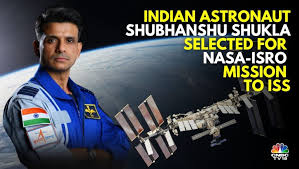
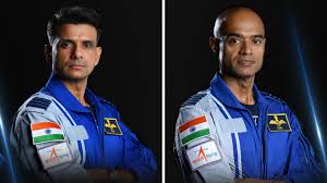
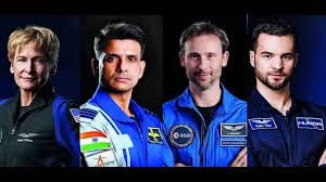
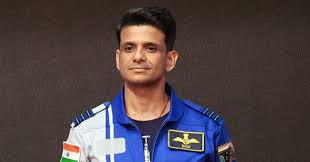
Indian Air Force Group Captain Shubhanshu Shukla will become the first Indian astronaut to visit the International Space Station (ISS) as part of Axiom Space’s Ax-4 mission, launching no earlier than May 29, 2025, from NASA’s Kennedy Space Centre in Florida aboard a SpaceX Crew Dragon spacecraft. Group Captain Prasanth Balakrishnan Nair is his backup. Shukla, a test pilot and Gaganyaan mission astronaut-designate, will serve as the mission pilot for the 14–21-day mission, commanded by former NASA astronaut Peggy Whitson, with mission specialists Sławosz Uznański-Wiśniewski (Poland) and Tibor Kapu (Hungary).
Shukla will conduct seven scientific experiments, including studies on muscle loss, microgravity screen time effects, and bio-farming, supporting ISRO’s Gaganyaan research. He will also promote Indian culture by carrying artefacts and practising yoga on the ISS. The Ax-4 mission, a collaboration between NASA, Axiom Space, and ISRO, includes 60 experiments from 31 countries. This historic mission, India’s first astronaut trip to the ISS and the second Indian in space since Rakesh Sharma’s 1984 Soyuz mission, highlights India’s rising prominence in global space exploration.
Established in 1969, the Indian Space Research Organisation (ISRO) has transformed India into a global space powerhouse. From humble beginnings with sounding rockets to executing complex interplanetary missions, ISRO’s journey reflects a blend of scientific excellence, frugal engineering, and ambitious vision.
The Indian Space Program: A Journey of Innovation and Ambition
Origins and Early Development. India’s space program began under the visionary leadership of Dr. Vikram Sarabhai, who recognised space technology’s potential to address national challenges like communication, education, and resource management. The Indian National Committee for Space Research (INCOSPAR), formed in 1962, laid the groundwork for ISRO. The first significant milestone was the launch of the Nike-Apache sounding rocket from Thumba in 1963, marking India’s entry into space research. ISRO’s early focus was on developing indigenous satellite and launch vehicle technologies. The launch of Aryabhata, India’s first satellite, in 1975 aboard a Soviet rocket, was a pivotal moment. By 1980, ISRO achieved a breakthrough with successfully launching the Rohini satellite using the Satellite Launch Vehicle (SLV-3), making India the sixth nation capable of independently launching satellites.
Building Capabilities. In the 1980s, ISRO developed the Polar Satellite Launch Vehicle (PSLV), a versatile rocket that became the backbone of India’s space program. The PSLV’s first successful launch in 1994 enabled India to place satellites in polar and geosynchronous orbits, supporting applications like remote sensing and communication. The INSAT series, starting with INSAT-1A in 1982, revolutionised telecommunications, television broadcasting, and weather forecasting, bridging India’s rural-urban divide. In the 1990s, ISRO expanded its Earth observation capabilities with the Indian Remote Sensing (IRS) satellite series. These satellites provided critical agriculture, disaster management, and urban planning data. The program’s emphasis on self-reliance led to developing the Geosynchronous Satellite Launch Vehicle (GSLV), designed to carry heavier payloads into geostationary orbits. Despite initial setbacks, the GSLV’s success in the 2000s bolstered India’s space ambitions.
Breakthroughs in the 21st Century. The 21st century marked a turning point for ISRO, with missions that showcased its technological prowess and global competitiveness. The Chandrayaan-1 mission, launched in 2008, was India’s first lunar probe. It made headlines with the discovery of water molecules on the Moon’s surface, a finding confirmed by its Moon Impact Probe. This mission, costing just $80 million, exemplified ISRO’s cost-effective approach, earning global acclaim. In 2013, ISRO achieved another milestone with the Mars Orbiter Mission (Mangalyaan), making India the first Asian nation to reach Martian orbit and the first globally to succeed on its maiden attempt. Mangalyaan, developed at a modest $74 million, demonstrated ISRO’s ability to deliver high-impact science on a lean budget. The mission’s longevity, with the orbiter still operational in 2025, underscores ISRO’s engineering excellence. ISRO’s Chandrayaan-2 mission 2019 aimed to soft-land a rover on the Moon’s South Pole. Although the Vikram lander crashed, the orbiter continues to provide valuable lunar data. The mission showcased India’s growing ambition to tackle complex challenges. In 2023, Chandrayaan-3 achieved a historic soft landing near the lunar South Pole, making India the fourth nation to land on the Moon and the first to explore this region. The Pragyan rover’s findings on lunar soil composition have added to global lunar science.
Societal Impact and Applications
ISRO’s space program extends beyond scientific exploration, delivering tangible benefits to Indian society. The INSAT and GSAT series have enabled tele-education and telemedicine, reaching remote areas with limited infrastructure. The Navic navigation system, operational since 2018, provides precise positioning services, enhancing transportation, agriculture, and defence sectors.
ISRO’s remote sensing satellites support disaster management by monitoring cyclones, floods, and droughts. The Cartosat and Resourcesat series aid in urban planning, water resource management, and crop forecasting, contributing to food security. ISRO’s data-sharing initiatives with global agencies also strengthen international cooperation in climate monitoring and disaster response.
The space program has spurred economic growth by fostering a domestic space industry. Companies like Antrix Corporation, ISRO’s commercial arm, and private startups like Skyroot Aerospace and Agnikul Cosmos are expanding India’s space ecosystem. ISRO’s technology transfers have enabled healthcare and renewable energy innovations, amplifying its socioeconomic impact.
Challenges
Despite its Successes, ISRO faces challenges. Limited funding, with a 2024-25 budget of approximately $1.6 billion, constrains its ability to scale ambitious projects compared to NASA ($25 billion) or China’s space program. Human spaceflight, a key frontier, has progressed slowly. The Gaganyaan mission, aiming to send Indian astronauts to low Earth orbit, faced delays due to technical complexities and the COVID-19 pandemic but is now targeted for 2026.
ISRO’s reliance on government funding limits its agility in a rapidly commercialising global space sector. While private sector participation grows, regulatory hurdles and bureaucratic processes hinder faster integration. Critics also point to occasional mission failures, like the GSLV’s early setbacks or Chandrayaan-2’s partial success, as areas needing improvement. However, ISRO’s ability to learn from failures and deliver subsequent successes reflects its resilience.
Future Prospects
ISRO’s roadmap is ambitious, with plans to solidify India’s position in global space exploration. The Gaganyaan mission will mark India’s entry into human spaceflight, with four astronauts training in collaboration with international partners. The Aditya-L1 solar observatory, launched in 2023, is studying the Sun’s corona, contributing to space weather forecasting. Chandrayaan-4, planned for 2028, aims to retrieve lunar samples, while a Venus orbiter mission is under development.
ISRO is also advancing its launch capabilities. The Small Satellite Launch Vehicle (SSLV) targets the growing demand for small satellite launches, while the Next-Generation Launch Vehicle (NGLV) will support heavier payloads, including space station modules. ISRO’s proposed Bharatiya Antariksh Station (Indian Space Station) by 2035 aligns with global trends in space infrastructure.
International collaboration is a priority, with ISRO partnering with NASA, ESA, and JAXA on missions like NISAR, a joint Earth-observation satellite. ISRO’s cost-effective model positions it as a preferred partner for emerging space nations and commercial entities. To stay competitive, the organisation also explores reusable launch vehicles and space robotics.
Conclusion
The Indian space program, driven by ISRO’s ingenuity and vision, has evolved from a nascent initiative to a global partner in space exploration. Its achievements, from lunar landings to interplanetary missions, reflect a commitment to scientific discovery and societal progress. While challenges like funding and commercialisation persist, ISRO’s track record of overcoming obstacles bodes well for its future.
As India aims for human spaceflight, a space station, and deeper planetary exploration, ISRO’s frugal yet impactful approach will continue to inspire. The program advances India’s technological capabilities and positions it as a key player in shaping the future of global space exploration, proving that ambition and innovation can transcend resource constraints.
Please Add Value to the write-up with your views on the subject.
For regular updates, please register your email here:-
Information and data included in the blog are for educational & non-commercial purposes only and have been carefully adapted, excerpted, or edited from reliable and accurate sources. All copyrighted material belongs to respective owners and is provided only for wider dissemination.
References:-
Times Now. (2025, April 18). Who Is Shubhanshu Shukla? Indian Astronaut-designate Group Captain to Fly to International Space Station In May.
ET Now. (2025, April 18). This is a major step for India’s space journey! Astronaut Shubhanshu Shukla will travel to space next month, the Modi government confirmed.
NDTV. (2025, April 18). Indian Astronaut-Designate Shubhanshu Shukla To Fly To Space Station in May.
The Times of India. (2025, April 18). An international space mission carrying Indian astronaut Shubhanshu Shukla is set to fly in May.
India Today. (2025, April 11). India’s Shubhanshu Shukla will study how screen time affects the human brain in space.
Republic World. (2025, April 2). IAF’s Shubhanshu Shukla to Become First Indian Astronaut Aboard SpaceX Dragon.
Chandrayaan Mission Pages: Detailed mission objectives, payloads, and outcomes for Chandrayaan-1, -2, and -3. Accessible via ISRO’s mission-specific portals: Chandrayaan-2, Chandrayaan-3.
Mishra, S. K. (2020): Indian Space Program: Evolution, Achievements, and Challenges. Journal of Space Exploration, 9(2), 45-56. A peer-reviewed article analysing ISRO’s growth and cost-effective strategies.
Narayanan, N. (2017): The Making of ISRO: Vikram Sarabhai’s Vision. HarperCollins India. A comprehensive book on the origins of ISRO and Sarabhai’s contributions.
The Hindu (August 24, 2023): “India Becomes First Nation to Land Near Lunar South Pole with Chandrayaan-3.” News article covering the historic Chandrayaan-3 landing.
Lele, A. (2014): Mission Mars: India’s Quest for the Red Planet. Springer. A detailed account of the Mars Orbiter Mission’s development and significance.
SpaceNews (March 15, 2025): “India Approves Chandrayaan-5 and LUPEX Mission with JAXA.” Reports on recent mission approvals and international collaborations.
ISRO Annual Report 2024-25: Outlines budget, ongoing projects, and commercial activities of Antrix Corporation. Available at: ISRO Annual Reports.
Bagla, P., & Menon, V. (2019): Reach for the Stars: The Evolution of India’s Space Programme. Bloomsbury India. A book detailing ISRO’s societal impacts and technological milestones.
NASA-ISRO Synthetic Aperture Radar (NISAR) Mission: Information on ISRO’s collaboration with NASA. Available at: nisar.jpl.nasa.gov.
Indian Air Force Group Captain Shubhanshu Shukla is set to make history as the first Indian astronaut to visit the International Space Station (ISS). He will embark on this journey as part of Axiom Space’s Axe-4 mission, scheduled to launch no earlier than May 29, 2025, from NASA’s Kennedy Space Centre in Florida aboard a Spacex Crew Dragon spacecraft. Group Captain Prasanth Balakrishnan Nair is designated as Shukla’s backup.
This marks India’s second astronaut in space, following Rakesh Sharma’s 1984 mission aboard a Soviet Soyuz spacecraft. Shukla, a decorated test pilot and astronaut-designate for India’s Gaganyaan mission, will be the mission pilot aboard a Spacex Dragon spacecraft, launching from NASA’s Kennedy Space Centre in Florida. The 14-day mission, commanded by former NASA astronaut Peggy Whitson, includes mission specialists Slawosz Uznanski-Wisniewski from Poland and Tibor Kapu from Hungary.
Scientific Endeavours. Shukla will conduct around seven scientific experiments, including studies on muscle loss, screen time effects in microgravity (Voyager Displays), and bio-farming, contributing to ISRO’s research for future crewed missions like Gaganyaan.
Cultural Representation. In addition to scientific work, Shukla plans to promote Indian culture by carrying artefacts and practising yoga aboard the ISS, symbolising India’s rich heritage in space exploration.
Significance for India. The mission, a partnership between NASA, Axiom Space, and ISRO, underscores India’s growing role in global space exploration. Ax-4 features 60 scientific studies from 31 countries. This mission marks a significant milestone for India, as it will be the first time an Indian astronaut visits the ISS and the first Indian in space since Rakesh Sharma’s 1984 mission. Group Captain Shukla’s participation is a precursor to ISRO’s upcoming Gaganyaan mission.
Please Add Value to the write-up with your views on the subject.
For regular updates, please register your email here:-
Information and data included in the blog are for educational & non-commercial purposes only and have been carefully adapted, excerpted, or edited from reliable and accurate sources. All copyrighted material belongs to respective owners and is provided only for wider dissemination.
References:-
Times Now. (2025, April 18). Who Is Shubhanshu Shukla? Indian Astronaut-designate Group Captain to Fly to International Space Station In May.
ET Now. (2025, April 18). This is a major step for India’s space journey! Astronaut Shubhanshu Shukla will travel to space next month, the Modi government confirmed.
NDTV. (2025, April 18). Indian Astronaut-Designate Shubhanshu Shukla To Fly To Space Station in May.
The Times of India. (2025, April 18). An international space mission carrying Indian astronaut Shubhanshu Shukla is set to fly in May.
News on Air. (2025, April 18). IAF’s Group Captain Shubhanshu Shukla to Fly to ISS Next Month on Axiom’s Ax-4 Mission.
India Today. (2025, April 11). India’s Shubhanshu Shukla will study how screen time affects the human brain in space.
Gadgets360. (2025, April 7). ISRO’s Shubhanshu Shukla Set to Make History with Space Station Mission in May.
ETV Bharat. (2025, April 7). Axiom Mission 4 Set To Launch In May 2025 With India’s Gaganyaan Astronaut Shubhanshu Shukla.
Republic World. (2025, April 2). IAF’s Shubhanshu Shukla to Become First Indian Astronaut Aboard SpaceX Dragon.