> ‘Taking someone for a ride’ is a fairly common expression, but taking someone for a trek? My poor unfortunate copilots have recently been getting a lot of it! We have this flight to Hong Kong which starts from Mumbai in the evening and makes it to Hong Kong early morning, the next day. As crew, we have about 24 hours of free time at Hong Kong before the next flight back. Having seen all the sights when we were flying the Airbus 310 ten years earlier, there is little else to do but sleep and watch TV or probably go down to the Citygate mall near our airport hotel.
Hong Kong airport used to be one of those tricky places to land into and there are numerous tales of pilots making hairy approach into Kai Tak. It was classified as the 6th most dangerous airport in the world. The runway extended into the sea with hills all around the other sides. The landing approach at Kai Tak was spectacular and world-famous – the aircraft would pass over the harbour, and then over the densely populated areas of Kowloon. Upon reaching a small hill marked with a huge orange and white checkerboard, used as a visual reference point, the pilot needed to make a 50° visual right turn to line up with the runway and complete the final leg at a fairly low height of 140 feet, to line up with the runway. This manoeuvre has become widely known in the piloting community as the “Hong Kong Turn” or “Checkerboard Turn”. Amongst passengers it became known as the “Kai Tak Heart Attack”
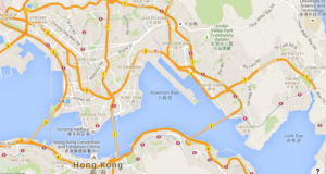
In part due to all this and a need to increase capacity, the British before handing over the crown colony back to the Chinese at the end of it’s 99 year lease decided to build a new airport. Since most of Hong Kong and the New Territories are either islands or hills or both, finding a flat piece of land large enough to accommodate a couple of runways and the associated infrastructure was going to be tricky. The Brits did the next best thing – combined the islands of Chek Lap Kok and Lam Chau off the largest island of Lantau, south of Hong Kong island.
 This is the island which you see from the airport hotel, easily spotted by two prominent hill features about 2700 feet high. A close look at the map of Lantau on Google maps shows a number of hiking trails running around the island. An Internet site dedicated to trekking on Lantau gives a description of the difficulty level, access points and approximate duration of each manageable segment on the 70 odd km long circular trail. A useful app which can be downloaded free for most places is one called maps.me. The salient feature of this app is that it works on downloaded maps and can thus be used offline. The maps here show trekking trails and bus stops, which I find extremely useful.
I had already completed two sections of the trail, one going beside Lantau peak and the other right over it, on earlier trips into Hong Kong. The one I was planning today was over the lesser Sunset peak. The trek segment was classified as ‘Very difficult’ and predicted to take almost three hours over a distance of about 7 km. I had already prepared my copilot in advance before leaving Mumbai to come prepared for the trek – mainly water bottles, a sturdy pair of shoes, a light jacket and a small backpack to carry a lunch pack. Other useful items would be a flashlight in case it got late, a camera and of course a fully charged smart phone preferably with an additional battery pack.
A short nap after the red eye flight into Hong Kong and my copilot and I were good to go at 1 pm. The hotel shuttle dropped us at the Citygate mall and from there it’s a short walk to the bus station where we pick up the number 3M bus to Mui Wo on the eastern side of the island. The planned trek segment starts at a place called Nam Shan where we alight.
My copilot is fairly enthusiastic and the initial section of the trek goes well. About a kilometre into the trek and we have been climbing steeply with more frequent breaks, ostensibly to take pictures but in reality to catch our breath!
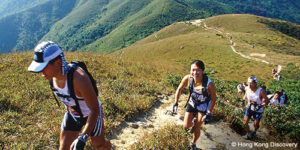
The good part of treks in Hong Kong is that the path is well made, with clear markings.
The climb is on rough cut stone slabs which provides ample support and a fair degree of confidence to the novice trekker. The signage helps too – they pop up every 500 m and give you some kind of encouragement to go on as the distance counter is seen to wind down.
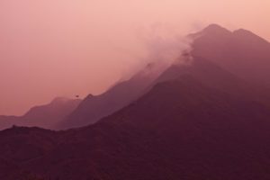
Surprisingly there are very few other hikers. The only group,we came across was a bunch of youngsters on a photo shoot – at least it looked like one, seeing the pro version of lenses they were using on their tripod mounted SLR. We took the opportunity to shoot some pics ourselves as well. The clouds were at times below us and the fair wind was pushing them along at a good pace. The strong winds were also being made use of by the odd bird on the look out for prey. The wind kept the bird at the same spot without even having to flap its wings! Lazy bird, we thought.
The marked trail actually bypassed Sunset Peak, but having climbed this far, we thought the additional climb to the peak was worth the effort, if nothing else but to take a pic on the trig point marking the elevation of the hill. The rough track going up Sunset peak was not too steep but unlike the earlier neatly laid out trail, it was a rough slippery affair. We scrambled up easily enough but coming down we had to clutch at straws along the path literally!
Going downhill is the real tricky part – it is stressful on the feet and your joints start to jar with the constant impact with hard rock. There is also the requirement of holding back on your downward momentum which is a strain on your calf muscles as well. The speeds are still good and we can spot the Tian Tan Buddha atop Ngong Ping in the distance. A helicopter buzzes by in the twilight, probably practising dusk landings on a helipad on Lantau hill across us.
We are down fairly quick and at the end of the trail near the bus stop, waiting for a bus. The return options are more with a choice of either the 3M, 11 or 23 bus. The first one is packed but we get the next one back to Tung Chung and on to the hotel. I thought it might be the last I see of my copilot with regard to trekking but a few days later I am heartened to get an SMS declaring that his aches and pains are gone and where are we going next?

Good one Jimmy. I envy you
Jimmy